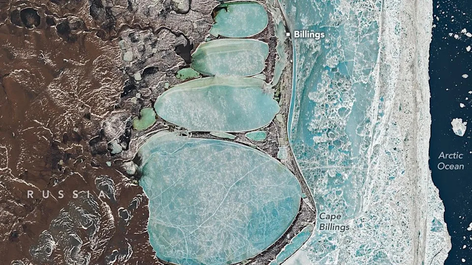
On June 16, 2025, Landsat 8 photographed a chain of frozen coastal lagoons near Billings and Cape Billings on Russia’s Chukchi Peninsula that align in a way that resembles a giant "snowman." Billings sits on a narrow spit where land, water and ice constantly interact, and persistent ice cover in June (average daily minimums near 30.9°F / −0.6°C) keeps these lagoons frozen. Landsat 8 — launched in 2013 and operated by NASA/USGS — provides consistent multispectral imagery (30 m) and a 15 m panchromatic band, enabling researchers to monitor Arctic coastal and permafrost change over time.
Giant 'Snowman' of Ice: Landsat 8 Captures Collapsed Lagoons Lining Siberia's Coast

Russia's coastline received a recent snowfall, resulting in a snowman shaped pile seen from space. . | Credit: NASA Earth Observatory image by Michala Garrison, using Landsat data from the U.S. Geological Survey.
On June 16, 2025, NASA's Landsat 8 satellite photographed a striking chain of elongated, oval coastal lagoons near Billings and Cape Billings on Russia's Chukchi Peninsula. From orbit the alignment of these frozen lagoons resembles a stacked "snowman" pressed against the shoreline — a whimsical visual that also reveals important details about Arctic coastal processes.
Billings was founded in the 1930s as a Soviet-era port and supply station. The settlement sits on a narrow spit that separates the Arctic Ocean from an adjoining chain of lagoons — an "edge zone" where land, water, ice and wind continually interact to reshape the terrain.
Although mid-June is typically one of the warmest periods of the year in this region, the scene remains dominated by ice. NASA reports that persistent ice cover is common here, with average daily minimum temperatures in June near 30.9°F (−0.6°C), conditions that allow lagoons and coastal waters to remain frozen late into the season.
About Landsat 8
Launched in February 2013 and operated jointly by NASA and the U.S. Geological Survey, Landsat 8 provides consistent, long-term observations of Earth’s surface. Its two primary instruments are the Operational Land Imager (OLI), which records multispectral bands at 30-meter (about 98-foot) resolution, and the Thermal Infrared Sensor (TIRS). Landsat also includes a 15-meter (about 49-foot) panchromatic band that offers finer spatial detail when needed.
Snow, land and ocean all meet in this satellite image. | Credit: NASA Earth Observatory image by Michala Garrison, using Landsat data from the U.S. Geological Survey.
Beyond spatial detail, consistency is the mission’s real strength. Landsat’s scheduled revisit cadence (16 days for Landsat 8 alone, with more frequent coverage when combined with other Landsat platforms) lets scientists compare "like with like" across seasons and years — a vital capability for detecting genuine environmental change rather than short-term variability.
The June 16 image freezes a moment when frozen lagoons, sea ice and shoreline features coexist, providing a useful snapshot of seasonal ice persistence in a region where the timing of freeze and thaw affects ecosystems, coastal erosion and human activities. Landsat’s moderate resolution is well matched to this task: broad enough to show the entire coastal system while detailed enough to distinguish lagoon ice, sea ice and land-surface features.
The segmented formation spans roughly 14 miles (22 kilometers) from top to bottom. For scale, the tallest constructed snowperson listed by Guinness World Records measured about 0.02 miles (37.21 meters) — making the Siberian "snowman" larger by many orders of magnitude, though formed by natural processes rather than human builders.
Why It Matters
Images like this are more than curiosities. They help researchers monitor permafrost stability, coastal erosion, the persistence of seasonal ice, and habitat conditions for Arctic wildlife. As the Arctic warms unevenly, regular, comparable satellite observations from platforms such as Landsat remain indispensable for tracking and understanding those changes.
Learn more: Landsat continues to be a cornerstone of Earth observation, supplying the long-term, consistent imagery that scientists rely on to study coastal dynamics, permafrost, and other rapidly changing components of the Arctic environment.
Help us improve.