The Landsat 8 image from Jan. 24, 2025, captures ribbon-like ice swirls on Lake Michigan beside a snow-covered Chicago during an extreme cold snap driven by a polar vortex expansion. Temperatures fell to about -33°F (-36°C) between Jan. 19 and Jan. 24, and roughly 20% of Lake Michigan was ice-covered at the time. GLERL scientists say offshore winds pushed shoreline ice into thicker, brighter bands; nearby Lake Erie was about 80% frozen and a freighter was briefly trapped in the pack.
Ethereal Ice Ribbons Sweep Past Chicago During Polar Vortex Cold Snap

The Landsat 8 satellite snapped a beautiful shot of swirling ice seemingly flowing away from Chicago during a cold snap in January 2025. | Credit: NASA/Landsat 8
This striking Landsat 8 image, captured on Jan. 24, 2025, shows delicate, ribbon-like bands of ice swirling across the surface of Lake Michigan beside a snow-blanketed Chicago. From orbit the patterns resemble turbulent clouds, but they are entirely made of lake ice formed and rearranged during an extreme cold snap linked to a polar vortex disruption.
What the Image Shows
The photograph reveals filamentary, cloudlike ice features hugging and then streaming away from the shoreline near Chicago. At the time the image was taken, roughly 20% of Lake Michigan was ice-covered — slightly above average for late January, according to NOAA’s Great Lakes Environmental Research Laboratory (GLERL).
How the Ice Formed
Between Jan. 19 and Jan. 24, 2025, a sudden expansion of the polar vortex brought frigid air southward. Temperatures in Chicago plunged to about -33°F (-36°C), NOAA reported. Those frigid conditions, combined with strong offshore winds, caused shore ice to form, pile up and then be pushed outward into long, ribbon-like bands. NASA's Earth Observatory notes that these flowing patterns look cloudlike from above but are composed of consolidated ice.
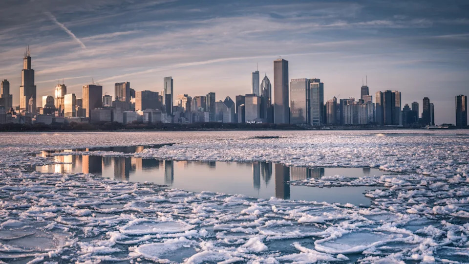
Up to 20% of Lake Michigan's surface was covered by ice during the 2025 cold snap, which was slightly over average for the time of year. This photo was taken during the winter of 2022. | Credit: Zhangying Huang via Getty Images
Expert Insight
Jia Wang, an ice climatologist at GLERL, explained that darker, wispy shore ice likely consolidated into thicker, rough-edged offshore structures that reflect more light and therefore appear brighter in satellite images.
Regional Impact and Context
Other Great Lakes were also affected: Lake Erie reached about 80% ice cover, and The New York Times reported a Canadian cargo freighter was trapped in the ice for three days. Lake Michigan normally reaches its peak ice extent in February or March, and uniform sheets of ice are more common than the filamentary patterns seen here.
Why This Matters
Satellite images like this help scientists track lake-ice dynamics, cold-season weather extremes and their local impacts on navigation and shoreline conditions. Images have also previously revealed unusual underwater and coastal features in Lake Michigan, such as the mysterious craters identified in 2024. On shore, extreme cold and winds can produce other unusual sights, including hoodoo-like frozen sand sculptures on beaches.
Location: Chicago, Illinois (approx. 41.86°N, -87.58°W).
Satellite: Landsat 8. Date: Jan. 24, 2025.
Help us improve.