
NASA's SWOT satellite and NOAA's DART buoys jointly captured the tsunami triggered by an 8.8-magnitude earthquake off Kamchatka in summer 2025. SWOT imaged a 75-mile-wide swath of the ocean while buoy data helped map a roughly 250-mile rupture that uplifted the seafloor by up to 13 feet. Published in The Seismic Record (Nov 2025), the study compares this event with a 1952 M9.0 rupture on the same fault and highlights how satellite–buoy synergy can improve tsunami monitoring and coastal warnings.
NASA's SWOT Captures a Monster Tsunami From an 8.8 Kamchatka Quake — Inside the Data

an artistic image of a tsunami wave - Fotokita/Getty Images
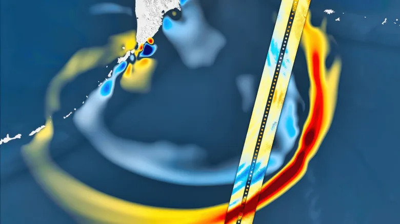
In the summer of 2025, an 8.8-magnitude earthquake struck off Russia's Kamchatka Peninsula and generated a large tsunami that propagated across the Pacific. NASA's Surface Water and Ocean Topography (SWOT) satellite — launched in 2022 — recorded the most significant seismic-related signal of its mission to date, providing an unprecedented view of the wave from space.
SWOT satellite imagery of the 2025 tsunami - BEST-BACKGROUNDS/Shutterstock
Researchers combined SWOT imagery with measurements from NOAA's Deep-ocean Assessment and Reporting of Tsunamis (DART) buoy network to reconstruct how the tsunami formed and evolved. DART sensors anchored to the seafloor measure tiny changes in water-column pressure and relay near–real-time data to surface buoys and satellites; these records were cleaned of ordinary tidal signals and inverted to estimate the seafloor displacement caused by the rupture.
an Entering Tsunami Hazard Zone warning sign - Smith Collection/gado/Getty Images
What the Data Showed
SWOT imaged a roughly 75-mile-wide swath of the ocean surface as the tsunami passed beneath, while nearby DART stations recorded the wave’s passage across the deep ocean. Using these complementary datasets, scientists mapped a rupture zone that extended about 250 miles and uplifted parts of the seafloor by as much as 13 feet. The combined observations allowed clear tracking of the tsunami’s shape, propagation speed, and dispersion even as it traveled rapidly across the ocean.
Context and Comparison
The analysis was published in The Seismic Record (November 2025). A notable element of the study is the comparison with a magnitude-9.0 earthquake that ruptured the same fault zone in 1952. The new analysis suggests that the 1952 event did not release all accumulated stress on the fault, which likely contributed to the 2025 quake occurring in the same region. The two ruptures also differed in depth and proximity to the seafloor — factors that influenced the tsunamis’ surface expressions — and, while both prompted evacuations, the 2025 tsunami caused less damage than the 1952 event.
Why This Matters
Beyond the scientific insights into fault behavior and tsunami generation, the study highlights the operational promise of coupling satellite altimetry with established buoy networks. SWOT’s high-resolution snapshots, when paired with reliable DART pressure records, can help refine tsunami models and potentially speed and improve coastal warning systems and emergency responses.
Bottom line: The 2025 Kamchatka event shows how modern satellites and ocean sensors together can transform tsunami observation and forecasting — offering faster, clearer data to protect coastal communities.


