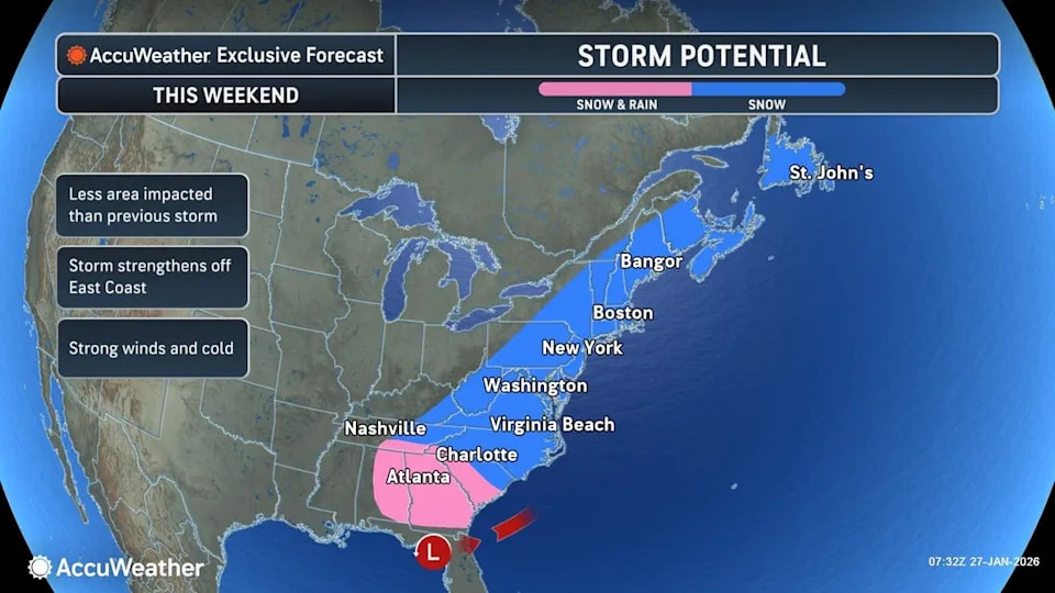
Forecasters say a new winter storm may form near the Southeast coast Friday, strengthen Saturday and peak Sunday as it tracks north along the Atlantic Seaboard, with lingering effects into Monday over parts of New England. The system could bring heavy snow, strong onshore winds and coastal flooding from the Outer Banks to New England. Final impacts depend on the storm’s track and how rapidly it intensifies; a close, rapidly strengthening storm could cause more widespread snow and significant coastal flooding.
Another Winter Storm Could Slam the East Coast This Weekend — Snow, Strong Winds and Coastal Flooding Possible

Residents in South Boston after more than a foot of snow fell on Jan. 26.(Charles Krupa/AP)
Forecasters warn a new winter storm may impact the U.S. East Coast this weekend, bringing the potential for heavy snow, strong onshore winds and coastal flooding. The alert follows a major storm last weekend that dumped snow and ice across a large area, knocked out power for hundreds of thousands of customers and created hazardous travel conditions.
“There is an increasing risk for a rapidly strengthening coastal storm this weekend,” said Carl Erickson, who oversees forecasting operations at AccuWeather. “Communities still digging out from last weekend’s system could face additional snow.”
Meteorologists say the system could form near the Southeast coast as early as Friday, intensify into Saturday and then track northward along the Atlantic Seaboard through Sunday, with lingering impacts into Monday for parts of New England.
Weekend Timeline
Friday night: Parts of the Southeast may see rain and pockets of wintry precipitation. AccuWeather forecasts rain is most likely south of Interstate 10 from Louisiana into Florida, while areas north of I-10 in parts of Louisiana, Alabama, Mississippi and Georgia could see a wintry mix of rain and snow.
Saturday: The storm could strengthen along the Southeast coast, producing heavier snowfall and increasing winds as it moves northeast.
Sunday: The system may reach peak intensity with the greatest threat of strong winds, significant snow across coastal and near-coastal areas, and coastal flooding at high tide.
Map of this weekend's potential winter storm impact.
Monday: The storm may linger over parts of New England into Monday morning before easing or moving offshore.
Potential Impacts
Strong onshore winds from the Outer Banks of North Carolina up through New England could produce power outages and coastal flooding at high tide. Forecasters say the eastern half of the U.S. will also remain very cold into next week, sustaining wintry conditions where precipitation occurs.
The final impacts will hinge on the storm's exact track and how rapidly it intensifies. A faster, stronger system that tracks close to shore could produce more widespread snow and moderate to major coastal flooding in some areas; a weaker or slower-developing system may track farther offshore and limit coastal impacts.
“How fast the storm strengthens will be a determining factor in the final track of the storm this weekend and whether or not it moves up the East Coast,” said AccuWeather long-range forecasting expert Paul Pastelok.
AccuWeather meteorologist Alex Sosnowski warned that if a rapid deepening (a "bomb cyclone") develops and stays close to shore, coastal flooding and beach erosion from North Carolina through Maine could be significant.
What You Should Do
Residents along the coast and in potentially affected inland areas should monitor local forecasts, prepare for the possibility of power outages, secure outdoor items, and avoid unnecessary travel during the storm. Check with local authorities for the latest warnings and guidance.
Sources: AccuWeather, National Weather Service Prediction Center.
Help us improve.