
A series of three fast-moving "clipper" storms will bring steady snow, strong lake-effect bands and sharp temperature drops across the Midwest and interior Northeast into early next week. Some lake-downwind areas and higher elevations could see a foot or more, while many areas will receive 1–6 inches. The National Weather Service has issued multiple advisories and warnings through Friday. Forecasters are also monitoring a separate Gulf Coast system that could bring mixed precipitation from southern Georgia to southern Delaware on Sunday.
Three Fast-Moving 'Clipper' Storms to Bring Lake-Effect Snow and Sharp Cold From Midwest Into Northeast

A series of winter storms bringing rounds of snow from the Midwest to the Northeast. (AccuWeather)(AccuWeather)
A succession of fast-moving winter systems, known as "clipper" storms, is expected to bring steady snow, intense lake-effect bands and rapid temperature drops across the Midwest and interior Northeast into early next week, meteorologists say.
What Forecasters Are Saying
"Three back-to-back rounds of wintry weather will bring snow to the interior Northeast and Great Lakes," AccuWeather meteorologist Brandon Buckingham wrote. "A foot or more of snow could pile up in areas downwind of the Great Lakes and across higher elevations by the end of the weekend."
The National Weather Service has issued winter weather advisories, lake-effect snow warnings and winter storm warnings through Friday for portions of the Great Lakes region and the interior Northeast.
Storm Tracks, Snow Totals And Timing
These clippers typically originate over central Canada and race southeast across the Great Lakes, producing steady, mostly pure snow due to the very cold air masses that accompany them. The NWS notes that clippers often produce fluffy, low–water-content snow that can accumulate quickly and be difficult to clear.
The first storm is expected to spread snow out of Duluth, Minn., beginning midday Thursday, with the precipitation potentially reaching Chicago and central Michigan by Thursday night and Cleveland by midday Friday. Many areas can expect 1–3 inches from this system, while portions of northern Minnesota, northern and western Michigan and northwestern Wisconsin could see 3–6 inches.
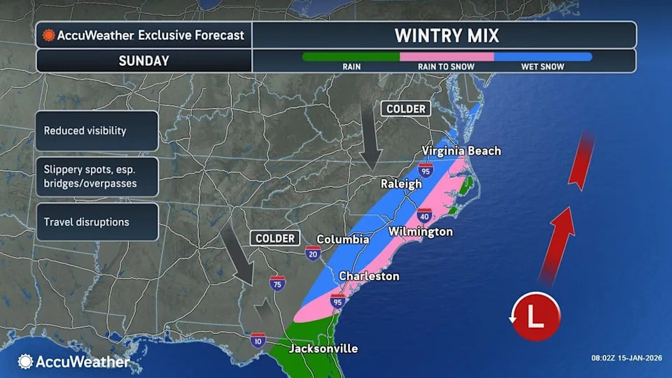
A map shows a wintry mix forecast for a developing storm along the Gulf Coast. (AccuWeather)(AccuWeather)
In regions downwind of the Great Lakes—including parts of Michigan, Indiana, Pennsylvania and New York—some locations could receive more than 6 inches, and a few spots may see a foot or more through Thursday night, AccuWeather meteorologist Elizabeth Danco said.
Behind the first system, a surge of colder air could produce an additional 1–6 inches of snow in places, with accumulations reaching as far south as the mountains of Tennessee and North Carolina and east into New York's Catskills and New England's Green and White Mountains.
Weekend Outlook And Additional Systems
Over the weekend the second and third clippers will continue to push through, bringing accumulating lake-effect snow to the interior Northeast. "Snow accumulations are possible in the Poconos, Catskills, and Berkshires this weekend," Buckingham said. Forecasters also expect a third clipper to sweep into the upper Midwest with additional snow from northern Minnesota into northern Michigan.
Separately, meteorologists are watching a developing system along the Gulf Coast that could produce a mix of snow, sleet and rain from southern Georgia up to southern Delaware on Sunday. That storm's future depends on whether it strengthens and tracks inland up the Southeast and along the coast or remains weak and heads out to sea, bypassing the I-95 corridor.
Impacts And Preparedness
Travel and safety: The cold air surges trailing each storm will cause quick freeze-ups and slippery conditions. Drivers should expect rapidly changing visibility and road surfaces where lake-effect bands set up. Slow down, increase following distances, and be prepared for sudden whiteout conditions.
Local advisories: Heed all National Weather Service and state or local advisories and warnings. If you live in lake-downwind areas or higher elevations, plan for difficult travel and heavier snow totals.
Bottom line: Prepare for multiple rounds of fast-moving snow and sharp temperature drops. Local accumulations will vary greatly—check the latest forecasts and alerts for your area.
Help us improve.


