
Ancient scholars like Eratosthenes demonstrated Earth’s roundness through geometry long before cameras existed; his third-century B.C. estimate of Earth’s circumference was strikingly close to the modern value. The first clear photographic hints of curvature came with aviation-era images — notably Captain Albert Stevens’s 1930 aerial photo (published 1931) and his 1935 balloon shot (published 1936) that showed the troposphere–stratosphere boundary. Later weather-satellite images in 1960 and Voyager 1’s distant “Pale Blue Dot” views confirmed Earth’s small, blue presence in space.
How Photographs Proved Earth's Curve — From Eratosthenes to the Pale Blue Dot

Collections of clouds hug Sicily (lower left) and Italy, which runs vertically through the center of this oblique scene, exposed by one the Expedition 40 crew members aboard the International Space Station at an altitude of 221 nautical miles. Credit: NASA.
Humans inferred Earth’s roundness long before cameras existed. In the third century B.C., the Greek scholar Eratosthenes estimated the planet’s circumference at roughly 24,000–29,000 miles by comparing the Sun’s angle at two different locations (Syene and Alexandria). His method yielded a value remarkably close to the modern figure of 24,901 miles and established a scientific foundation for a spherical Earth.
Despite these early mathematical proofs, clear visual evidence of Earth’s curvature did not appear until the age of aviation and aerial photography. On this date in 1930, attendees at a meeting co-hosted by the American Association for the Advancement of Science saw an influential aerial photograph taken by Captain Albert Stevens, an officer in the U.S. Army Air Corps and an early aerial photographer. Stevens shot the image while flying about 21,000 feet over Argentina; it was later published in the May 1931 issue of National Geographic.
In that photograph, faint ridges of the Andes appear roughly 300 miles away — features NASA says would lie “well below the expected horizon if the Earth were flat.” The image subtly shows the planet’s curvature, though the frame spans only about 1/360 of Earth’s circumference.
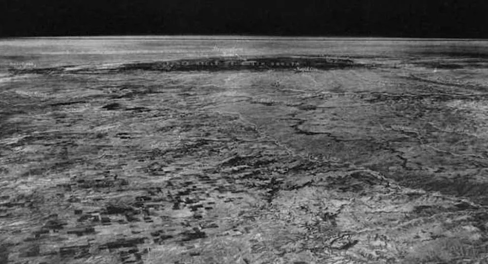
The first image illuminating the division between the lower two layers of Earth’s atmosphere.Credit: Albert W. Stevens/Wikimedia Commons.
Stevens returned with an even more striking image in 1935: a photograph taken from a balloon at a record altitude of 72,395 feet. That shot was the first to clearly show the boundary between the troposphere and the stratosphere and included recognizable terrain such as the Black Hills and the Bighorn Mountains. It was published in National Geographic in May 1936.
Over the following decades, spaceflight extended our viewpoint still further. The first weather-satellite image of Earth (from TIROS-type satellites) arrived in 1960, and about three decades later the Voyager 1 probe returned the famous distant view that came to be known as the “Pale Blue Dot,” emphasizing how small Earth appears from deep space.
“With sounding rockets and then spacecraft returning photographs from ever-greater distances from the planet, we could begin to see the Earth first as a full disk, then as a smaller and smaller blue oasis against the emptiness of space,” NASA wrote. “Through these images, we gained a better understanding of Earth’s, and therefore of our own, place in the universe.”
These milestones — from Eratosthenes’ geometric reasoning to aerial photographs and finally to images taken from space — together trace how observation and technology built an incontrovertible visual case for a spherical Earth.
Lead image: NASA
Help us improve.


