NASA's Earth Observatory satellite images collected over the past year reveal how human activities — from urban and agricultural expansion to rising greenhouse‑gas emissions — are reshaping Earth's surface. The photos show widespread land conversion, shrinking water bodies, and climate‑linked changes such as retreating ice and altered vegetation. They also spotlight regional crises, including severe drying in parts of Iran after depletion of a key water resource. Together, the images underscore the global and local impacts of human-driven change.
Seen From Space: Satellite Photos Reveal How Humans Are Reshaping Earth

A plankton bloom in the Baltic Sea in July. Scientists say manure and fertilizer runoff from European farms is fueling blooms. NASA
Humans are altering Earth's surface at an unprecedented scale — clearing vast tracts of wilderness for farms and cities and releasing large volumes of heat‑trapping gases into the atmosphere. The consequences of these changes are now visible from orbit.
Satellite Evidence Of a Changing Planet
Over the past year, NASA's Earth Observatory has shared a series of satellite images that document the expanding human footprint. From sprawling urban growth and agricultural expansion to shrinking lakes and melting ice, these images make the scope of change unmistakable.
What The Photos Show
- Land Conversion: Forests and other wildlands are being replaced by farms and cities, creating striking patterns visible from space.
- Water Loss: Some regions show dramatic drying of rivers and lakes after water resources were overexploited.
- Climate Signals: The effects of rising greenhouse‑gas concentrations—such as shrinking ice sheets, shifts in vegetation, and changing surface temperatures—are detectable in satellite records.
The impact of these enormous changes can be seen from space.
Regional Examples
Alongside global trends, the images call attention to regional crises. One striking example is severe drying in parts of Iran after the depletion of a treasured water resource—an emblematic case of how local mismanagement and broader climatic shifts combine to produce stark, visible change.
These satellite photos do more than illustrate problems: they provide timely, visual evidence that can guide policy, conservation, and adaptation efforts worldwide.
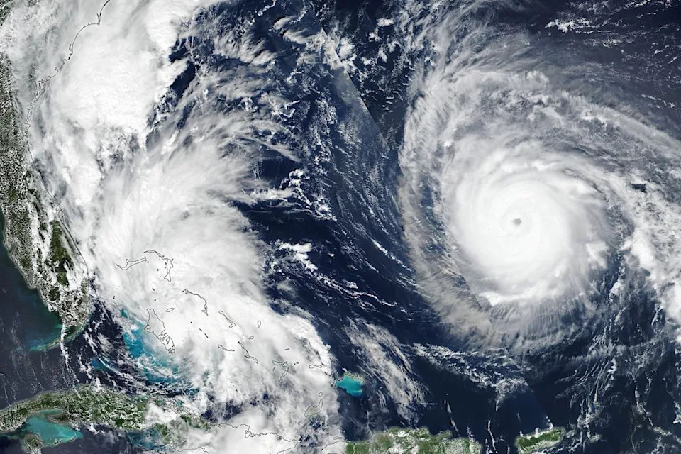
Hurricane Imelda (left) and Hurricane Humberto (right) approaching Florida in September. A recent study found that, as oceans warm, the Atlantic is increasingly seeing not just one, but two or more hurricanes spin up at the same time. NASA
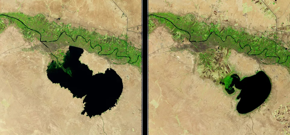
Habaniya Lake in Iraq in 2020 (left) and 2025 (right). The lake, fed by the Euphrates River, has been withered by a drought. The drought, which scientists say is fueled by warming, has desiccated lakes, marshes, and wetlands across the country. In August, the Iraqi government said the country's water reserves had hit an 80-year low. NASA
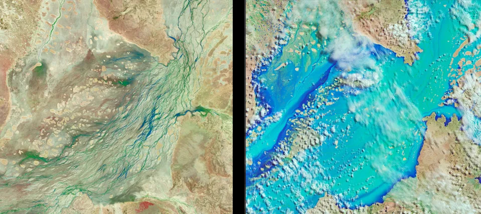
Water channels in Queensland, Australia, before (left) and after (right) extreme rainfall in March fueled the worst flooding the region has seen in half a century. Scientists say that warming likely exacerbated the flooding, which killed 33 people. NASA
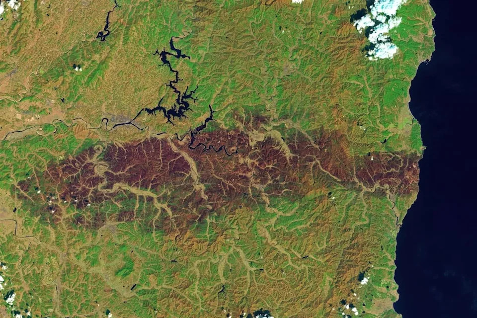
A false-color image of South Korean forests scorched by wildfires in March. An analysis found that warming doubled the odds of the hot, dry, windy weather that gave rise to the fires, which burned close to 260,000 acres and killed 32 people. NASA
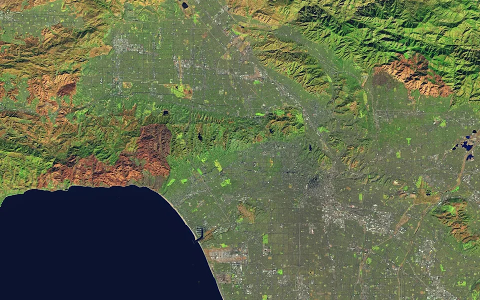
A false-color image of burn scars in Los Angeles, left by the Palisades Fire (left) and Eaton Fire (right), in January of last year. In 2024, L.A. saw record rainfall, which fueled the growth of grasses and shrubs, followed by an exceptionally arid fall, which left dense vegetation to dry out. A recent report found warming made the L.A. wildfires twice as likely and 25 times larger. The fires burned more than 50,000 acres and killed an estimated 440 people. NASA
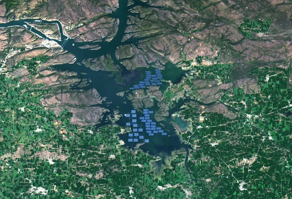
A massive floating solar array in a reservoir on India's Narmada River. The installation, completed earlier this year, covers 210 acres. The installation is another sign that, even as emissions rise and weather grows more extreme, the world is making progress on climate change. In the first half of last year, renewables supplied more power than coal for the first time globally. NASA
Help us improve.