
The University of Haifa developed an AI-driven system that uses high-resolution drone imagery and machine learning to map individual stones and wall segments at archaeological sites. Tested at nine Israeli sites, it detected roughly 350,000 stones—about 20% tied to walls—and performed well despite vegetation and varied soils. The method produces precise site plans in minutes, helping archaeologists target excavations, reduce disturbance, and explore new spatial research questions.
AI and Drones Reveal Hidden Architecture: University of Haifa Maps 350,000 Ancient Stones

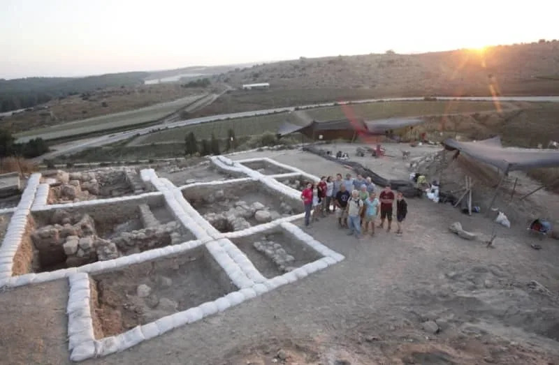
Drone imagery of an archaeological site. (photo credit: Erel Uziel/TPS-IL)
A new computational system developed at the University of Haifa is transforming how archaeologists document and analyze ancient ruins by combining high-resolution drone imagery with machine-learning algorithms. What once looked like scattered rubble from the ground can now be rendered into coherent, measurable plans in minutes.
“Sites that appear on the surface as scattered stones suddenly become coherent, organized spaces, and it saves a lot of research time,” said Dr. Yitzchak Jaffe of the University of Haifa’s School of Archaeology and Maritime Cultures, a co-author of the study.
How it works: Researchers stitched hundreds of aerial photographs into precise orthomosaics and elevation models, then divided those maps into many small tiles to train two separate machine-learning models. One model detects individual building stones and the other recognizes wall segments. Both were trained on thousands of manually labeled examples. The system then cross-references stone detections with wall-segmentation layers to produce a detailed site plan that pins each stone to an exact location and—when applicable—associates it with a specific wall segment.
A team of archaeologists, led by Prof. Yosef Garfinkel of the Hebrew University of Jerusalem’s Institute of Archaeology and Prof. Michael Hasel at Southern Adventist University in Tennessee, revealed extensive ruins of a Canaanite temple dating (credit: Courtesy)
Field Testing and Results
The tool was evaluated in the peer-reviewed Journal of Archaeological Science and tested at nine archaeological sites across Israel. In total it identified roughly 350,000 building stones, about 20% of which were classified as part of wall structures. The researchers report robust performance even in challenging conditions such as dense vegetation, heterogeneous soil colors, and partial preservation.
Why This Matters
By integrating stone-level mapping with wall segmentation, the platform reveals construction types, architectural patterns, and settlement organization over whole sites—insights that previously required extensive excavation to obtain. The added spatial precision helps archaeologists prioritize high-potential areas, plan more strategic and less invasive excavations, and better preserve sensitive contexts. It also enables new research questions about building density changes, reuse of materials, neighborhood layout, and shifts in construction techniques over time.
Practical response: Hai Ashkenazi, manager of Geoinformatics at Israel’s Antiquities Authority, called the tool potentially "very helpful," noting his team is testing compatibility with their files and terrain types.
Research team: The project includes contributions from Dr. Yitzchak Jaffe and doctoral researcher Erel Uziel, among others, and represents a promising step toward faster, more accurate, and less invasive archaeological documentation.
Help us improve.


