Satellite imagery and resident testimony reviewed by Reuters show that, in December, Israeli forces repositioned concrete markers meant to mark a U.S.-backed ceasefire "Yellow Line" deeper into Hamas-held areas of Gaza. In Al-Tuffah the markers were moved about 200 metres and at least 40 buildings were razed; similar shifts — up to 390 metres — were recorded in Khan Younis. Israel denies intentionally shifting the line, while Hamas and Gaza officials say the moves are compressing the population into a narrow coastal strip and amount to ceasefire violations.
Satellite Images and Testimony Show Israel Pushed Its 'Yellow Line' Deeper Into Gaza Neighbourhoods
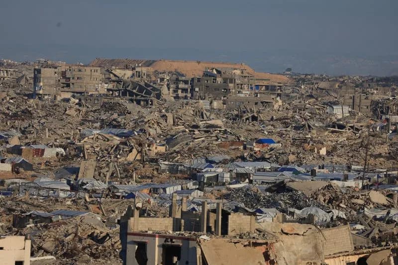
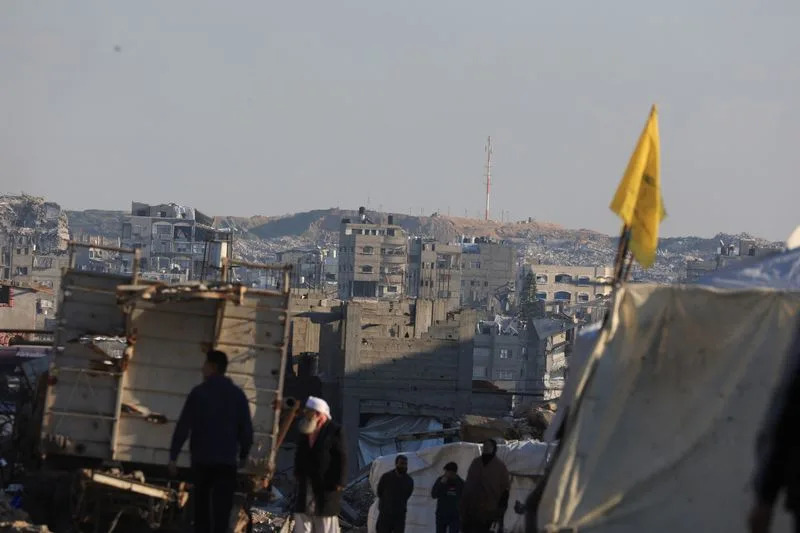
A general view of destroyed houses in areas marked as 'Yellow Line' by the Israeli military, in east of Gaza City, January 16, 2026. REUTERS/Dawoud Abu Alkas
Satellite imagery reviewed by Reuters and testimony from residents indicate that, in December, Israeli forces repositioned the concrete markers that were intended to mark a U.S.-backed ceasefire "Yellow Line" deeper into areas controlled by Hamas in Gaza. The move — and subsequent clearing of territory — appears to have razed buildings and displaced civilians, raising questions about whether it violated the terms of the ceasefire arrangement.
What The Imagery Shows
In Al-Tuffah, a historic quarter of Gaza City reduced to rubble after repeated strikes, satellite images taken on December 2 and December 13 show concrete blocks initially placed on the Hamas-controlled side of the mapped Yellow Line and then moved roughly 200 metres further west. Reuters' analysis of the imagery found at least 40 buildings demolished between the newly positioned blocks and the previously mapped line. Few structures remained standing in that corridor.
The imagery also documents similar placements elsewhere in Gaza. In Khan Younis, southern Gaza, photos from December show one block about 390 metres beyond the mapped line and another about 220 metres beyond it. The images further record the removal of multiple buildings and the dismantling of two tent clusters meant to shelter displaced people. At least six large fortifications were observed built within 700 metres of the line on the Israeli side, including a position near Beit Hanoun about 264 metres from the mapped line.
A general view of destroyed houses in areas marked as 'Yellow Line' by the Israeli military, in east of Gaza City, January 16, 2026. REUTERS/Dawoud Abu Alkas
Local Testimony
Residents said they felt forced to flee after the blocks were moved. Manal Abu Al-Kas, who had sheltered in eastern Al-Tuffah, told Reuters that two of her sons had been killed and buried there and that she, her husband and another son (both with amputated legs) left after the yellow barriers appeared. She said they only fled in January because shells were falling on their homes.
“If there weren't shells falling on us in our homes, we wouldn't have left our house,” Manal Abu Al-Kas said.
Official Responses
The Israeli military told Reuters that claims it was shifting the Yellow Line were incorrect, saying it marks the line "visually in accordance with the terrain and topographical conditions, and in the course of necessary operational activity to address threats in the area." The military did not provide evidence to substantiate the denial and declined to answer detailed questions about the specific movements in Al-Tuffah, Khan Younis or the newly built fortifications. A military source said published depictions of the Yellow Line were "illustrations" and that obstacles such as buildings can prevent exact placement of markers.
Hamas spokesperson Hazem Qassem warned that the de facto enlargement of the zone controlled by Israeli forces was pushing thousands westward and risked confining Gaza's population to a narrow coastal strip.
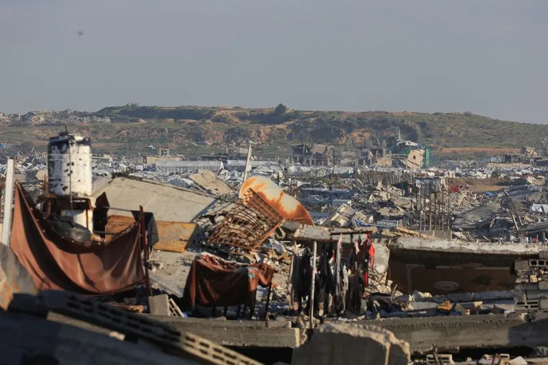
Displaced Palestinian people walk near the area marked as 'Yellow Line' by the Israeli military, in east of Gaza City, January 16, 2026. REUTERS/Dawoud Abu Alkas
Context And Casualties
The movements occurred under a U.S.-backed ceasefire framework based on a 20-point plan promoted by then-President Donald Trump, which called for halting military operations and "freezing" battle lines until conditions allowed staged withdrawals linked to Hamas disarmament. Trump later announced steps including a Palestinian technocratic committee and a so-called "Board of Peace" to move the deal forward.
Gaza health officials report that more than 460 Palestinians have been killed by Israeli fire since the October ceasefire came into force, while militants have killed three Israeli soldiers in the same period. The broader conflict began after a Hamas-led cross-border attack on October 7, 2023, which Israel says killed about 1,200 people; Gaza health authorities say Israel's subsequent offensive has killed some 71,000 Palestinians.
Outstanding Questions
The satellite images alone do not reveal how buildings were demolished; previous operations have used a mix of aerial strikes, controlled detonations and bulldozers. Reuters asked the Israeli military why the blocks were moved and how the demolitions were carried out but received no detailed explanation or evidentiary support for the denial. The implications for the ceasefire — and for civilians sheltering near the line — remain contested by both sides.
Reporting: Reporting and analysis were based on satellite imagery reviewed by Reuters and interviews with residents. Additional reporting contributed from Beirut, London, Cairo and Jerusalem.
Help us improve.