
Summary: A powerful atmospheric river will bring heavy rain, flooding risk and feet of Sierra Nevada snow to California through Christmas, while multiple storms may deliver snow, sleet and freezing rain across the mid‑Atlantic and Northeast. At the same time, a surge of unseasonably warm air could produce record‑warm conditions for many central U.S. cities. With AAA projecting about 122.4 million holiday travelers, widespread weather disruptions are possible.
Holiday Travel Alert: Atmospheric Rivers Slam California, Northeast Faces Wintry Mix, Central U.S. Near Record Warmth

Weather across the United States will vary dramatically in the final days before Christmas, raising travel safety concerns. A powerful atmospheric river will drench parts of California with heavy rain, damaging winds and feet of mountain snow, multiple storm systems will bring a wintry mix to the Northeast, and a broad surge of unseasonably warm air will push temperatures well above average across much of the central U.S.
California: Flooding Rain, High Winds and Heavy Sierra Snow
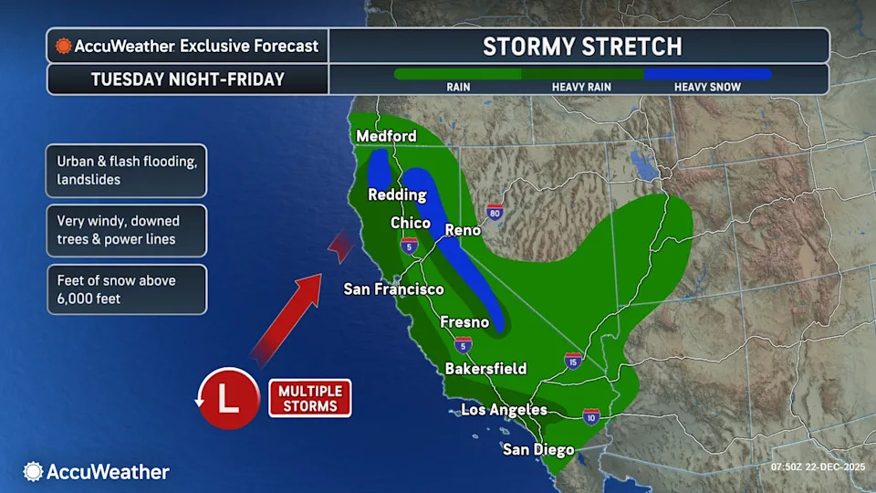
Meteorologists warn a second, intense atmospheric river will impact California through Christmas Day, producing heavy rainfall, strong winds and a heightened risk of flooding during the holiday travel peak.
c
Forecast highlights:
- Northern California (Sacramento Valley and San Francisco Bay Area): 2–4 inches of rain forecast from Tuesday night into early Friday.
- Los Angeles Basin: 4–8 inches of rain possible; AccuWeather notes this could be two to four times December's typical total of ~2.48 inches.
- Transverse Ranges: 6–12 inches of rain expected.
- Sierra Nevada: Several feet of snow likely in spots. Donner Pass (I‑80) could see 2–4 feet from late Wednesday into Friday, with travel potentially halted and resort access blocked.
The first atmospheric river earlier this week produced locally more than 6 inches of rain over 48 hours, causing at least one fatality and multiple water rescues in Redding, California. As of Tuesday morning, flood watches covered roughly 41 million people in parts of Southern and Northern California and neighboring Nevada. The National Weather Service has issued winter storm warnings for portions of northern and eastern California.

c
Northeast: Multiple Storms Bring Snow, Sleet and Freezing Rain
Several storm systems will traverse the Midwest and Northeast around Christmas, bringing a mix of precipitation types that could disrupt travel.
What to expect:

c
- Beginning Tuesday, air from the Great Lakes will push snow, sleet and freezing rain into the mid‑Atlantic and Northeast.
- Central and south‑central Pennsylvania could see up to 0.10 inches of ice accumulation from freezing rain, creating slick, hazardous conditions.
- Northern New York, northeastern Pennsylvania and much of New England: roughly 1–3 inches of snow. Higher elevations (Adirondacks, Catskills, Green and White Mountains) may receive 3–10 inches.
- A second storm around Christmas (late Wednesday into Thursday) will mostly produce drizzle from the Ohio Valley into the mid‑Atlantic and Northeast, with a third system arriving Christmas night into Friday bringing accumulating snow from parts of the Plains into the Northeast.
“Snow, sleet, and freezing rain could cause some big travel problems on Friday and Saturday. It could turn into a travel nightmare for some people trying to see family members or return home after Christmas Day,” said AccuWeather meteorologist Paul Pastelok.
Central U.S.: Unseasonable Warmth May Break Christmas Records
A broad plume of warm air will push temperatures well above normal across much of the central and south‑central U.S. Meteorologists say hundreds of millions of Americans will experience above‑average temperatures this week, and dozens of cities could record their warmest Christmas on record.
Cities cited at risk for record warmth include Kansas City (Mo.), Tulsa (Okla.), Wichita (Kan.), Albuquerque (N.M.) and Amarillo (Texas). AccuWeather meteorologist Alyssa Glenny said, “Close to two dozen states… are forecast to experience temperatures that are 15–30 degrees above the historical average by Christmas Day — warmth comparable to late April or early May.”
Travel Impacts And Advice
AAA projects about 122.4 million Americans — a 2.2% increase from 2024 — will travel at least 50 miles from home between Dec. 20 and Jan. 1, raising the risk that weather-related delays will affect many holiday plans.
- California: Flooding, road closures and heavy mountain snow may severely disrupt road and air travel. Expect hazardous conditions on mountain passes and possible closures to resort access.
- Northeast: Snow, ice and freezing rain could cause major travel disruptions on roads and at airports, especially Friday and Saturday after Christmas.
- Central U.S.: Unseasonable warmth may create low clouds and fog from the Gulf Coast to the Ohio Valley and Atlantic Coast, increasing the potential for flight delays and reduced visibility on roads.
Travelers should monitor local National Weather Service alerts, check airline and road conditions before departing, and allow extra time for holiday trips.


