The 28-acre Riverland Oaks parcel on James Island faces a proposal to build 95 townhomes that has split neighbors and city officials. Developers say the plan meets stormwater rules and preserves 42% open space, includes a seven-acre detention pond and targets a 50% runoff reduction; opponents worry new construction will worsen frequent flooding and sewage-contaminated standing water. Adam Friend has gathered more than 1,700 petition signatures urging the city to buy and conserve the land, while Charleston's Water Plan warns James Island is low-lying and vulnerable to rising seas and stronger storms.
James Island Debate: 28 Acres, 95 Townhomes and a Fight Over Flood Risk and Conservation
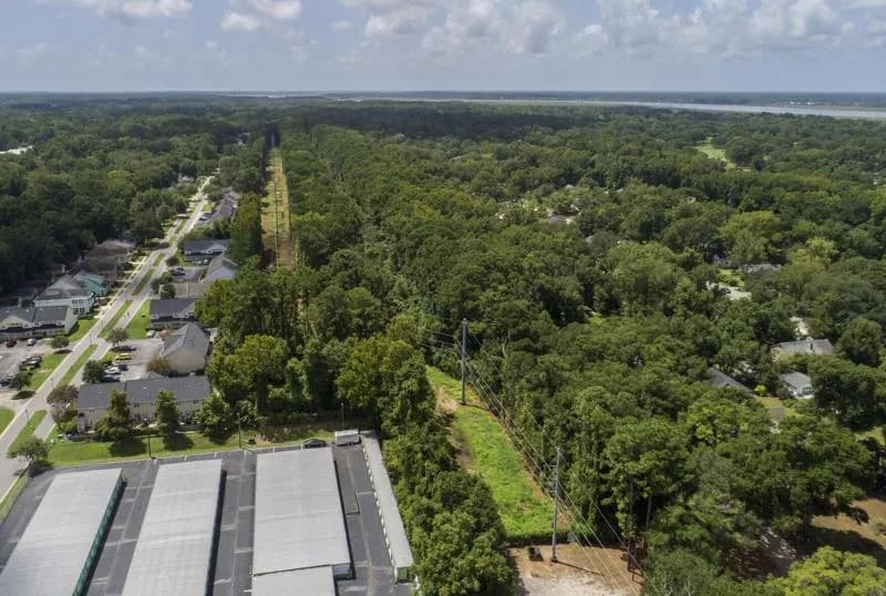
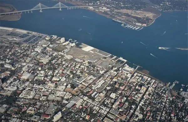
A developer is seeking permission to put 95 townhomes on this roughly 28 acre parcel of land behind The Charleston Pour House (the back parking lot is pictured at center front) just off Maybank Highway on James Island. Gavin McIntyre/Staff
JAMES ISLAND — A narrow, 28-acre stand of urban forest behind The Charleston Pour House and adjacent to Maybank Highway has become the flashpoint in a years-long debate about development, flood risk and conservation on low-lying James Island. The Riverland Oaks proposal would replace the woods with 95 townhomes and a network of streets linking Maybank Highway to Pawpaw Street — a plan that residents and city officials sharply disagree about.
Neighbors Say Flooding Will Get Worse
Residents living near the parcel say the neighborhood already suffers recurring inundation and that new construction could increase flooding and sewage-related contamination of standing water. Adam Friend, a local resident and county council candidate who launched a Change.org petition calling for the city to buy and preserve the property, said the tract is "literally the last green sliver" in the area. As of Aug. 7, his petition had more than 1,700 signatures.
"I'm 6'6" and I've got pictures of water up past my knees," Friend said, adding concerns about wastewater mixing with stormwater during floods. "We are going to see more water rise, and that could be the difference between, 'Oh, it got under my house,' and 'Oh, it got in my house.'"
Developers Say The Project Meets Rules
Developers and city staff counter that the plan complies with Charleston's stormwater regulations and, by their calculations, would reduce runoff from the site. Chris Donato, a civil engineer with Sitecast, LLC, told the Planning Commission the project has been under review for more than a decade and has been updated as zoning and stormwater codes changed.
Key elements of the current plan include:
- 42 percent of the site preserved as open space, intended for public use such as a farmers market;
- Density reduced to about 3.7 units per acre, down from the allowable six units per acre;
- Approximately seven acres dedicated to a detention pond designed to manage stormwater;
- Of 42 so-called "grand" trees on the parcel, developers say only three—graded "F" by city staff—would be removed.
Donato also noted changes to runoff requirements for special protection areas: a 2020 ordinance required projects to reduce runoff by 50 percent, but the city revised that rule in April to require only a 20 percent reduction for such areas. He said the Riverland Oaks plan continues to target the earlier 50 percent reduction.
Long Review, Local Precedent
City planning staff describe the proposal as one of the most reviewed subdivisions of its size in recent decades. On July 15, the Planning Commission voted in favor of the project and sent it to the Technical Review Committee for further vetting.
Neighbors point to local examples where flood-prone subdivisions were converted to open space. In West Ashley's Shadowmoss neighborhood the city worked with FEMA to acquire repeatedly flooded properties and repurpose them as passive parkland to improve resilience.
Broader Context: An "Evolving" Sea Island
The controversy over this 28-acre parcel reflects a larger struggle as Charleston balances growth with the realities of climate change. Charleston's Water Plan calls James Island "one of the lowest, flattest of the areas in Charleston," with the Maybank Highway corridor reaching roughly 18 feet above sea level. The plan projects about 1 foot of sea-level rise in the next 25 years and 2 to 4 feet by 2070, forecasts that would permanently alter many low-lying neighborhoods and could increase storm impacts.
The Water Plan recommends limiting density on low ridges and treating the Maybank corridor as a buffer zone rather than a target for high-density growth, while pointing to higher ground elsewhere — such as Clements Ferry Road on the Cainhoy peninsula — for future concentrated development.
What Comes Next
The Riverland Oaks proposal has been debated on and off since at least 2015 and remains under city review. Opponents press for a municipal buyout and permanent conservation, while developers emphasize compliance with current rules and mitigation measures. As sea levels rise and extreme weather becomes more frequent, decisions about this parcel may set precedent for how Charleston balances housing demand with long-term resilience.
Help us improve.