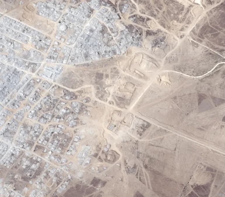
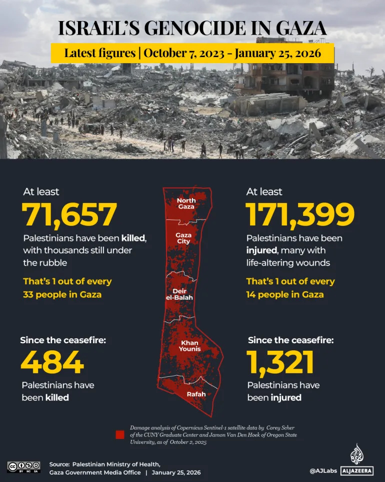
The "yellow line" is a de facto Israeli buffer zone created during the first phase of the October ceasefire that runs 1.5–6.5 km inside Gaza and covers about 58% of the territory. It effectively divides Gaza into an Israeli-controlled east and a west that faces fewer movement orders but continuous threats of strikes and displacement. The line has driven repeated forced evacuations, destroyed livelihoods and contributed to massive destruction — with UN officials estimating seven-plus years to clear 60 million tonnes of rubble. Humanitarian agencies report severe psychological harm, particularly among children, and extensive agricultural losses.
Inside the 'Yellow Line': How a De Facto Israeli Buffer Zone Is Reshaping Life in Gaza

(Al Jazeera)
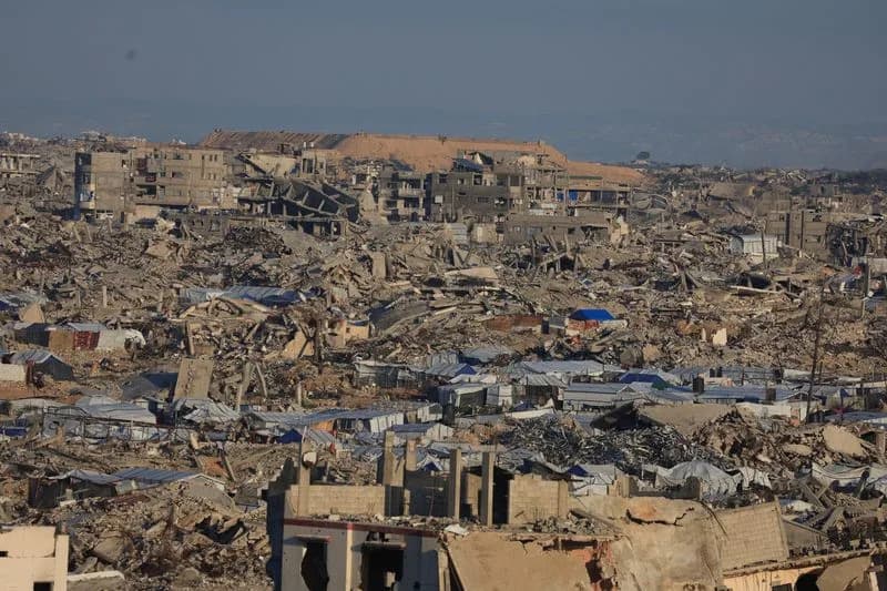
Just metres from a row of yellow-painted concrete barriers that mark the Israeli army’s latest redeployment in eastern Gaza City, Zaid Mohammed — a displaced Palestinian father of four — shelters with his family in a small tent amid flattened neighbourhoods and ruined homes.
What Is the "Yellow Line"?
The so-called "yellow line" is a de facto demarcation created during the first phase of the October ceasefire. Israeli military maps show the line running between 1.5 km and 6.5 km (0.9–4 miles) inside Gaza from the Israeli boundary and covering roughly 58 percent of the enclave. For residents it functions like an internal border, dividing Gaza into an eastern zone under effective Israeli military control and a western zone with fewer movement orders but persistent risk of air strikes and forced displacement.
Daily Life Under a Shifting Boundary
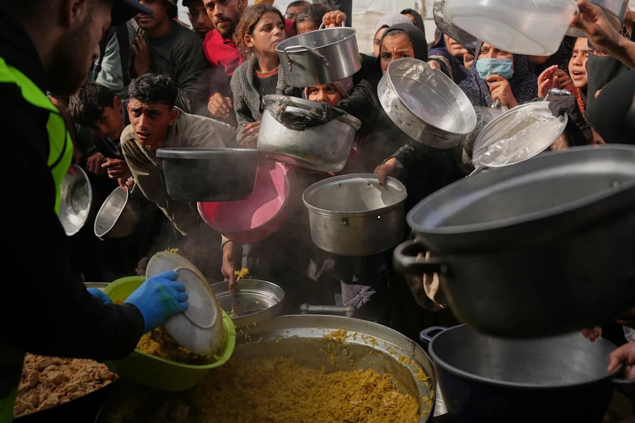
Zaid’s tent stands amid rubble strewn across streets and courtyards. A UN official recently estimated it would take over seven years to clear more than 60 million tonnes of debris across Gaza. International agencies report that more than 80 percent of the enclave’s buildings have been destroyed or damaged during the conflict that has affected more than 2.3 million residents.
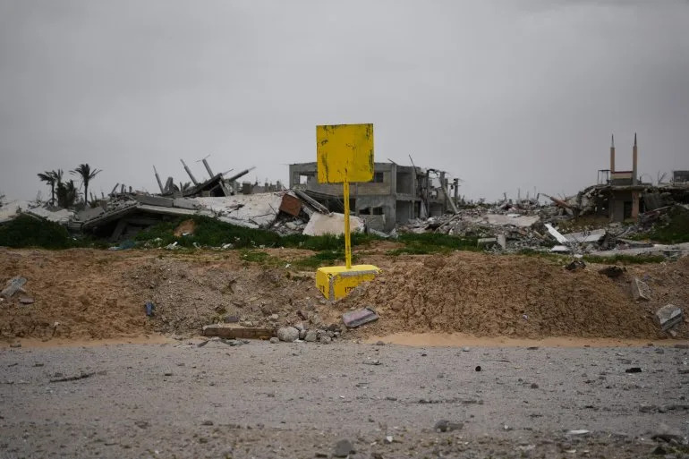
A yellow block demarcating the “Yellow Line,” is visible in Khan Younis in southern Gaza Strip on Thursday, January 22, 2026. [Abdel Kareem Hana/AP Photo]
“Shelling and gunfire continue around the clock,” Zaid told Al Jazeera, pointing toward the eastern horizon where dust plumes rise from nearby explosions.
Residents living near the yellow line say they frequently wake to gunfire, small detonations or the buzz of drones overhead. Some describe seeing soldiers and tanks only a few hundred metres away. At night, a lack of electricity plunges neighbourhoods into darkness while military flares briefly light the sky.
Forced Displacement, Maps and Uncertainty
The line has been established through a series of forced-displacement orders issued over the course of the war. Those orders were often circulated via leaflets, phone messages or online maps while air strikes were ongoing, giving civilians little time to move to safety. The UN Office for the Coordination of Humanitarian Affairs (OCHA) has documented periods when >70 percent of Gaza was under evacuation orders or deemed unsafe.
Although the yellow line shifts on maps — expanding, contracting and relocating — its effects are constant: it dictates which streets feel safe, which homes are abandoned and when it is time to flee. In many areas no physical markers exist, forcing residents to rely on memory, sound and word of mouth to judge where it is safe to go.
INTERACTIVE-GAZA CEASEFIRE-jan 25, 2026_Death toll tracker-1765554400
Human Costs: Trauma, Livelihoods and Food Security
Mental-health professionals working with the World Health Organization and UNICEF report elevated rates of anxiety, insomnia and trauma, particularly among children who learn new "maps" of safety and which routes to avoid. Aid workers warn that normalising danger produces long-term psychological harm.
The yellow line also cuts into livelihoods: farmers can often see their fields but cannot access them, workplaces vanish if they lie too close to unsafe zones, and food production suffers. The Food and Agriculture Organization (FAO) has documented extensive farmland loss linked to restricted access, shelling and military activity near these boundary areas.
Why It Matters
During a December visit, the Israeli military chief of staff, Lt. Gen. Eyal Zamir, described the yellow line as "a new border line." Whether formalised or not, the line now shapes where people live, how they move, whether they can rebuild and how humanitarian agencies operate. Even during temporary lulls in fighting, the yellow line remains embedded in daily life across much of Gaza.
Key figures: roughly 58% of Gaza covered by the yellow line; more than 80% of buildings damaged or destroyed; over 60 million tonnes of rubble; many periods when >70% of territory was under evacuation orders.
For families like Zaid’s, the yellow line is not just a mark on a map — it is a daily reality that frames safety, survival and hope amid ongoing destruction.
Help us improve.