
NASA’s SPHEREx has completed its first full-sky survey after launching in March and beginning operations in May. The mission produced 102 wavelength maps during six months of observations and captured roughly 3,600 images per orbit from a polar path that crosses nearly 15 times per day. During its two-year primary mission SPHEREx will perform three additional all-sky scans, producing richer maps that will help probe the universe’s earliest moments and the evolution of galaxies over 13.8 billion years.
NASA’s SPHEREx Completes First Full-Sky Map — A Stunning New View of the Universe

A map of the entire sky over Earth in 102 colors as seen by SPHEREx. | Credit: NASA/JPL-Caltech
NASA’s SPHEREx observatory has produced its first complete map of the sky above Earth, delivering a visually striking survey and a powerful new dataset for cosmology and astrophysics.
Launched in March and beginning routine operations in May, SPHEREx — the Spectro-Photometer for the History of the Universe, Epoch of Reionization, and Ices Explorer — scanned the entire celestial sphere during its first six months of science observations. The mission generated 102 separate maps, each at a different wavelength, enabling scientists to study the sky in unprecedented spectral detail.
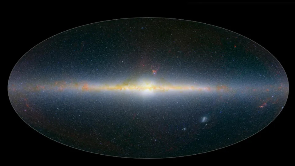
The infrared colors of the SPHEREx cosmic map. | Credit: NASA/JPL-Caltech
What the Map Reveals
Beyond its aesthetic appeal, SPHEREx’s first all-sky map will help researchers address major questions in cosmology and galaxy evolution. The data will be used to probe conditions in the very early universe, inform models of how the three-dimensional distribution of hundreds of millions of galaxies formed, and trace how the chemical elements essential for life were created and dispersed across cosmic history.
How SPHEREx Works
SPHEREx operates from a polar orbit, passing from the North Pole to the South Pole nearly 15 times each day. As it sweeps the sky, the conical observatory captures roughly 3,600 images per orbit. The motion of Earth around the Sun shifts SPHEREx’s field of view over time, allowing the instrument to build a complete, multiwavelength picture of the sky.

SPHEREx orbiting the Earth | Credit: NASA
Operations that began in May produced the first full-sky map this month. During its two-year primary mission, SPHEREx is expected to perform three additional full-sky scans; these successive surveys will be combined with the initial map to produce ever more detailed and sensitive views of the sky.
“It’s incredible how much information SPHEREx has collected in just six months — information that will be especially valuable when used alongside our other missions’ data to better understand our universe,” Shawn Domagal-Goldman, director of the Astrophysics Division at NASA Headquarters, said. “We essentially have 102 new maps of the entire sky, each one in a different wavelength and containing unique information about the objects it sees. I think every astronomer is going to find something of value here.”
“SPHEREx is a mid-sized astrophysics mission delivering big science,” JPL Director Dave Gallagher added. “It’s a phenomenal example of how we turn bold ideas into reality, and in doing so, unlock enormous potential for discovery.”
As teams analyze the full dataset, astronomers expect SPHEREx results to complement other missions and ground-based surveys, opening new avenues for discoveries about the universe’s origin, structure, and chemical evolution.


