With under 48 hours until a potential Northeast winter storm, the U.S. GFS and European (ECMWF) models show very different outcomes: the GFS paints a near‑coastal bomb cyclone with heavy snow, while the Euro keeps the system offshore and much weaker. The split reflects small but crucial differences in how each model handles Canadian energy, southern‑jet disturbances, and a Rocky Mountain ridge. NOAA forecasters are using all models and ensembles, prioritizing impact‑based messaging and communicating the range of possible outcomes rather than a single inch total.
T‑48 Hours: Models Split — Coastal Bomb Cyclone Or Light Snow For The Northeast?
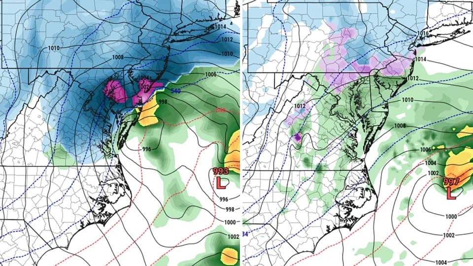
Depictions of the potential storm showing blue for snowfall, green for rain and yellow for heavy rain. The GFS model is on the left and the European is on the right. - Pivotal Weather
With less than 48 hours until a potentially major winter storm arrives, forecasters face a stark dilemma: two leading computer models are projecting very different outcomes for the Mid‑Atlantic and New England.
GFS vs. Euro: Two Very Different Pictures
The American Global Forecast System (GFS) has been showing a powerful, near‑record "bomb cyclone" tracking close to the coast and bringing heavy, potentially crippling snowfall to cities from Washington, D.C., to Boston. By contrast, the European model (ECMWF) and several other guidance systems have consistently kept the main low farther offshore, signaling a much weaker event and only light snow for the big population centers.
Those differences are not trivial. Early Friday guidance illustrated the split: the GFS projected roughly 18 inches for Washington, D.C., while the Euro suggested about 4 inches. In Philadelphia the gap was even wider in those runs — roughly 29.2 inches from the GFS versus about 1.7 inches from the Euro.
Why The Models Disagree
The divergence stems from subtle differences in how each model handles several interacting pieces of the atmosphere: pockets of energy diving south out of Canada, disturbances rippling along the southern jet near the Gulf Coast, and a ridge of high pressure over the Rockies. Small shifts in timing or position of any of these features can mean the difference between an all‑out coastal blizzard and a modest, inland snow event.
It's important to note these contrasts are not simply the result of missing observations or staffing issues: both major models draw from the same observation networks. Likewise, the growing use of AI tools in forecasting adds analysis capability but does not eliminate the need to interpret why numerical models produce different solutions.
How Forecasters Are Responding
At the NOAA Weather Prediction Center, meteorologists are examining every model and ensemble system available and emphasizing impact‑based messaging over a single, precise snowfall number. Cody Snell, a meteorologist at the center, said forecasters are focused on communicating risks and uncertainty rather than getting pulled into a model head‑to‑head.
"We look at every model, every ensemble system available to us, and usually the answer is somewhere in between," Snell said. "The main thing is crafting a clear message about impacts versus promising a specific inch total."
When guidance conflicts, forecasters often present a most‑likely scenario (for example, light to moderate snow) while noting a low‑probability, high‑impact outcome (coastal bomb cyclone with heavy snowfall). That approach protects against both under‑ and over‑preparation but can leave public messaging feeling broad — for instance, headlines listing a range such as 4 to 18 inches.
Track Record And What To Watch Next
This winter the European model and some of its AI‑enhanced systems have generally outperformed the GFS, which leads many forecasters to give the Euro more weight when models disagree. Still, model divergence can persist nearly to a storm's onset, so officials and the public should watch for updated guidance and impact statements as the event draws nearer.
Over the next day, meteorologists will lean on ensemble runs, observational updates, and expert judgment to refine forecasts and public advisories. Because the potential economic and safety impacts of a large Northeast storm are substantial, officials will likely emphasize preparedness while clarifying the uncertainty.
Help us improve.