
NASA’s Mars Reconnaissance Orbiter has captured its 100,000th HiRISE image after nearly 20 years in orbit and more than 450 terabits of data returned. The Oct. 7 image shows dunes, sand-filled plains and ancient craters in Syrtis Major, about 50 miles southeast of Jezero Crater. The site was nominated by a high school student via HiWish, underscoring public participation. HiRISE’s archive and 3D models continue to reveal active surface changes and help prepare for future human missions.
NASA's Mars Reconnaissance Orbiter Captures 100,000th HiRISE Image — A Milestone for Mars Exploration

This view of a region called Syrtis Major is from the 100,000th image captured by NASA’s Mars Reconnaissance Orbiter using its HiRISE camera. Over nearly 20 years, HiRISE has helped scientists understand how the Red Planet’s surface is constantly changing.
NASA’s Mars Reconnaissance Orbiter (MRO), which entered service above Mars in November 2006, has reached a major milestone: it captured its 100,000th image from orbit. Over nearly two decades, MRO has relayed more than 450 terabits of data, transforming our picture of Mars and guiding ongoing and future exploration.
The milestone image was taken on October 7 by MRO’s High Resolution Imaging Science Experiment (HiRISE). The photograph shows sprawling sand-filled plains, steep migrating dunes and several ancient impact craters in the Syrtis Major region. That scene lies roughly 50 miles southeast of Jezero Crater, the landing site where NASA’s Perseverance rover continues surface investigations.
HiRISE images do more than showcase the Red Planet’s dramatic landscapes: the exceptional detail in each frame helps researchers study active surface processes and prepare for eventual human missions. The HiRISE archive is invaluable for spotting changes over time, mapping safe rover routes and selecting scientifically interesting targets.
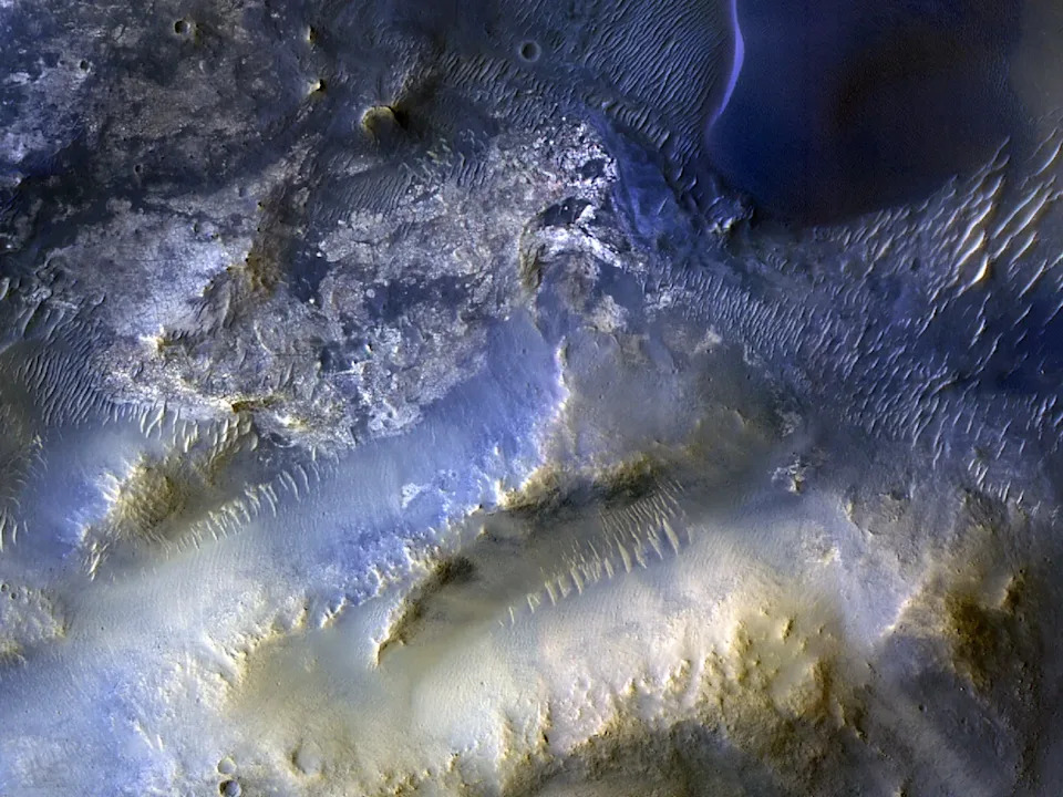
Syrtis Major is a region located about 50 miles southeast from the area being explored by the Perseverance rover. Credit: NASA / JPL-Caltech / University of Arizona
“HiRISE hasn’t just shown how different the Martian surface is from Earth; it has also revealed how that surface changes over time,” said MRO project scientist Leslie Tamppari of NASA’s Jet Propulsion Laboratory. “We have observed dune fields marching with the wind and avalanches careening down steep slopes.”
Notably, the site featured in the 100,000th image was nominated not by mission control but by a high school student through HiWish, NASA’s public portal that allows students, amateur scientists and members of the public to suggest imaging targets on Mars. Public participation and rapid data releases have been hallmarks of HiRISE operations.
“Rapid data releases, together with imaging targets proposed by the broader science community and the public, have been a hallmark of HiRISE,” said Shane Byrne, HiRISE’s principal investigator at the University of Arizona in Tucson. “A hundred thousand images like this one have made Mars more familiar and accessible for everyone.”
Beyond still images, Byrne and colleagues have produced high-resolution three-dimensional models that let anyone take virtual flyovers of Martian terrain, offering immersive views that support both research and public outreach.
Why this matters: The longevity and productivity of MRO and HiRISE give scientists an unprecedented time-lapse view of Mars—showing active processes and improving our ability to plan safe, science-rich missions, including the prospect of human exploration.


