
NASA's Mars Reconnaissance Orbiter has taken its 100,000th HiRISE image, a milestone averaging about 5,000 photos per year since arriving at Mars in March 2006. The Oct. 7 image captures Syrtis Major, a dune- and crater-strewn region southeast of Jezero Crater. Repeated imaging by MRO reveals migrating dunes, avalanches and other seasonal surface changes. The orbiter also imaged interstellar comet 3I/ATLAS at roughly 19 million miles, confirming its comet-like appearance.
NASA's Mars Reconnaissance Orbiter Reaches 100,000 HiRISE Images — New View of Syrtis Major

This shot of the dune-strewn region called Syrtis Major is the 100,000th image captured by NASA's Mars Reconnaissance Orbiter using its HiRISE camera. | Credit: NASA/JPL-Caltech/University of Arizona
NASA's Mars Reconnaissance Orbiter (MRO) has reached a major milestone: its HiRISE camera captured the 100,000th image of the Red Planet. That tally averages roughly 5,000 photos per year — about 417 per month or nearly 14 per day — since MRO entered Mars orbit in March 2006.
The milestone image, taken on Oct. 7, shows a shadowed, rugged landscape of mesas, impact craters and wind-shaped dunes in the Syrtis Major region. Syrtis Major lies just southeast of Jezero Crater, the ancient lakebed currently explored by NASA's Perseverance rover, and appears as a prominent dark patch in telescopic views from afar.
Why This Image Matters
MRO has repeatedly imaged Syrtis Major. Those observations have revealed slowly migrating sand dunes, avalanches and other seasonal changes driven by Martian winds and temperature cycles. Tracking these changes helps scientists understand the processes that shape Mars today and how its environment evolved over time.
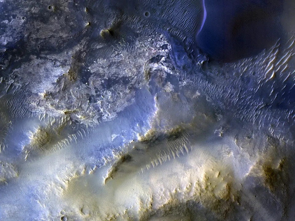
The full view of Syrtis Major | Credit: NASA/JPL-Caltech/University of Arizona
"HiRISE hasn't just shown us how different Mars' surface is from Earth's — it has also revealed how that surface evolves over time," said Leslie Tamppari, MRO's deputy project scientist at NASA's Jet Propulsion Laboratory. "We've watched dune fields march with the wind and avalanches sweep down steep slopes."
Mission Background And Other Observations
Launched from Florida on Aug. 12, 2005, and inserted into Martian orbit on March 10, 2006, MRO continues to map and monitor the planet as long as the spacecraft remains healthy. While its primary role is high-resolution surface imaging, MRO occasionally points away from Mars to capture other targets.
In October, the orbiter imaged interstellar comet 3I/ATLAS when the object passed roughly 19 million miles (about 30 million kilometers) from the spacecraft — a closer pass than the comet's approach to Earth on Dec. 19. Although MRO was not designed to study small, fast-moving interstellar visitors at extreme range, its observations helped confirm 3I/ATLAS behaved like a natural comet, showing a compact nucleus surrounded by a bright coma of gas and dust.
What Comes Next: MRO will keep photographing Mars, providing an increasingly rich archive that helps scientists study active processes such as dune migration, slope failures and seasonal changes across the planet.


