Researchers analyzed observations from 1982–2023 and found atmospheric rivers can either intensify or suppress marine heatwaves depending on season and region. In winter, active atmospheric rivers often appear about two days before heatwave peaks and can reduce ocean heat loss through warm, humid air. In summer, cloud shading from atmospheric rivers commonly blocks solar heating and slows heatwave development. The results suggest season-specific atmospheric river tracking could improve marine heatwave forecasts.
How Atmospheric Rivers Can Both Trigger and Suppress Marine Heatwaves, Study Finds
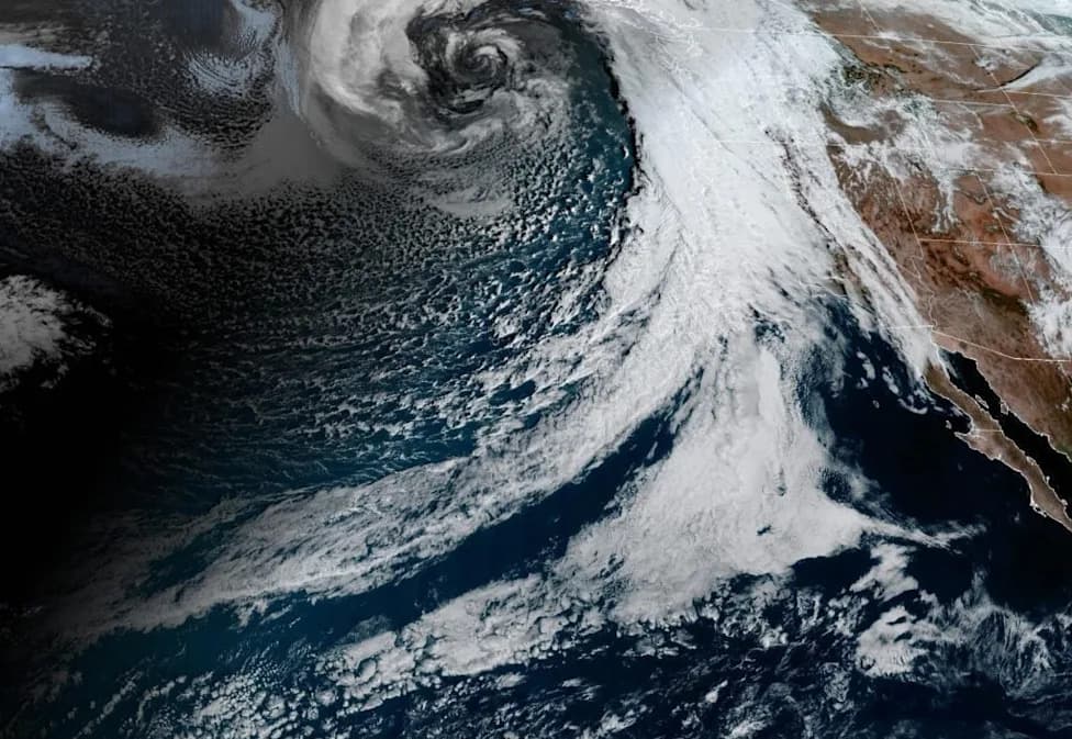
A 42-year study finds that rivers of moisture in the sky can warm or cool ocean heatwaves depending on season. (CREDIT: NOAA)
Atmospheric rivers — long, narrow corridors of warm, moisture-rich air — do more than dump rain on land. New research from Duke University shows these systems can either amplify or dampen marine heatwaves over the North Pacific and North Atlantic, with their net effect depending strongly on season and region.
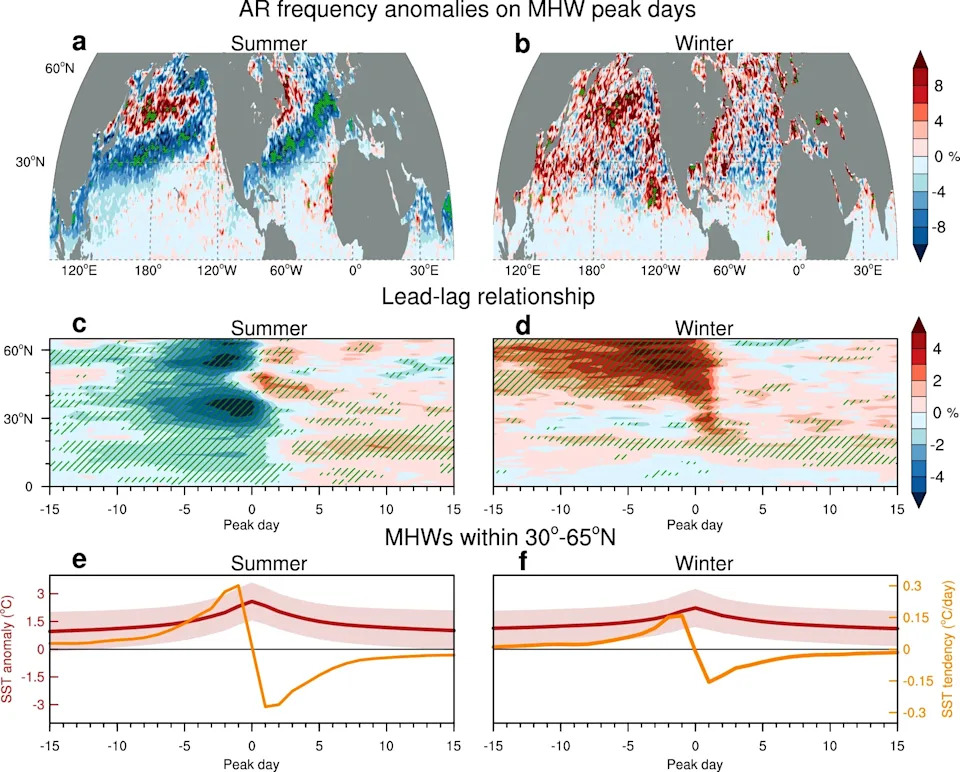
Relationship between atmospheric rivers (ARs) and marine heatwaves (MHWs). (CREDIT: Nature)
Key Findings
The study analyzed observations from 1982–2023 and found a clear seasonal contrast: in winter, unusually active atmospheric rivers often appear about two days (and sometimes more than a week) before marine heatwaves reach their peak, helping the ocean surface warm. In summer, by contrast, increased atmospheric river activity tends to bring thicker cloud cover that shades the sea surface and slows or suppresses heatwave development; consequently, summer heatwave peaks more often follow periods with fewer atmospheric rivers.
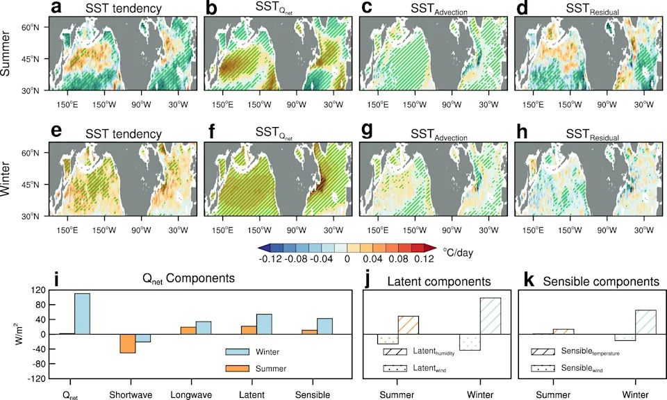
Spatial decomposition of sea surface temperature (SST) tendency based on ocean mixed-layer heat budget analysis and components of net surface heat flux (Qnet) anomalies during atmospheric river (AR) days. (CREDIT: Nature)
Why The Effect Flips With The Seasons
Cloud shading in summer: During summer months incoming solar radiation is strong, so clouds associated with atmospheric rivers block sunlight and produce a net cooling effect across large areas of both basins. A notable exception lies roughly between 40°–50°N, where warm, humid air and air–sea heat exchange can offset reduced sunlight and still favor warming.
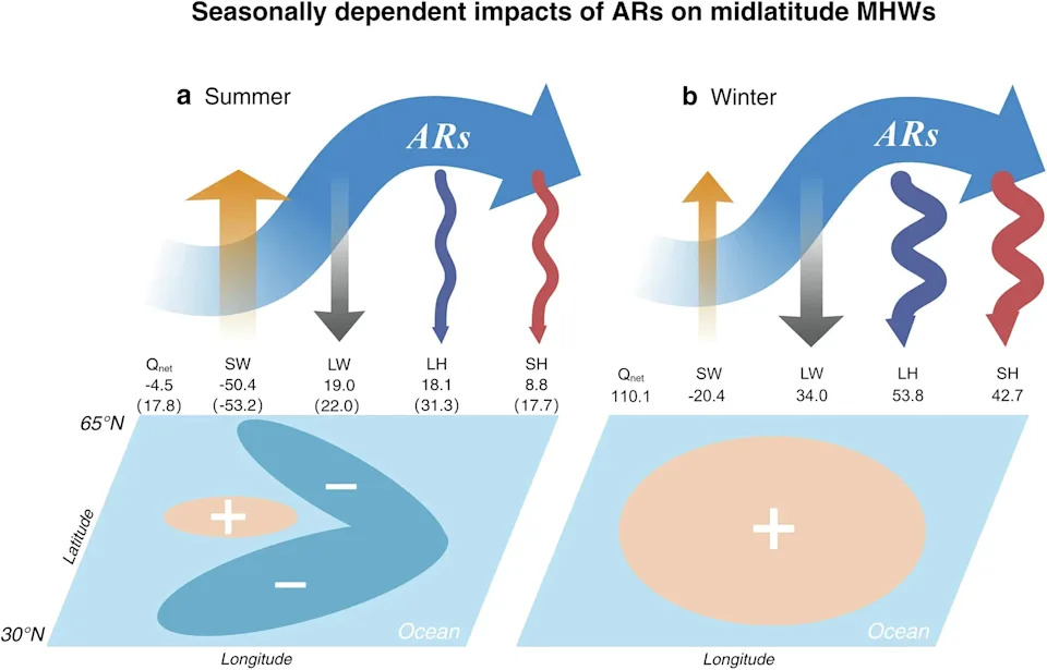
Mechanistic schematic for the fingerprints of atmospheric rivers (ARs) on marine heatwaves (MHWs). (CREDIT: Nature)
Warm, humid air in winter: In winter, solar input is much weaker and cloud shading matters less. The warm, moisture-rich air carried by atmospheric rivers reduces upward longwave radiation and weakens evaporative cooling at the sea surface; this can outweigh the heat loss from stronger winds and lead to net surface warming before heatwave peaks.
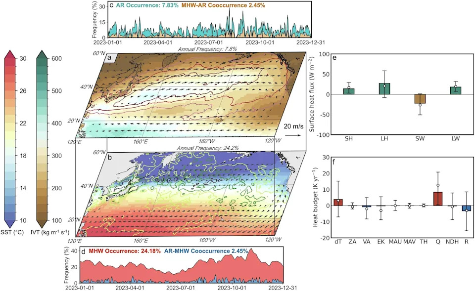
Representation of ARs, MHWs, and associated physical factors in 2023. (CREDIT: Nature)
Methods And Mechanisms
The authors used satellite, shipboard and other observations to identify atmospheric rivers and marine heatwaves in extratropical regions of the North Pacific and North Atlantic. Heat-budget analysis showed that changes in net surface heat flux (air–sea heat exchange) explained most of the observed sea surface temperature responses, while horizontal ocean advection and unresolved ocean processes played smaller or damping roles.
“We wanted to see if these interactions between atmosphere and sea surface might play a role in marine heatwaves,” said Shineng Hu, assistant professor of climate dynamics at Duke’s Nicholas School of the Environment. Coauthor Suqiong Hu added: “Cloud cover tends to increase with atmospheric rivers, causing the sea surface to cool. However, warm and moist air associated with atmospheric rivers cause the sea surface to warm up.”
Implications And Uncertainties
Because atmospheric rivers spend much of their lives over the ocean, they repeatedly interact with the surface and can meaningfully alter sea temperatures. Incorporating atmospheric river activity into marine heatwave forecasting—especially in winter, when a strong pre-peak signal was observed—could provide earlier warnings for fisheries, coastal managers and industries.
However, the study does not claim every atmospheric river produces a heatwave. Regional conditions and the specific structure of each atmospheric river matter. The authors also note that how this relationship will evolve under future warming remains uncertain: warmer air may intensify atmospheric rivers, potentially strengthening winter warming effects, but changes in clouds, winds, storm tracks and ocean state could alter summer outcomes.
The research is published online in the journal Nature.
Help us improve.