Satellite data from the U.S.-European Sentinel-6 Michael Freilich show a large pulse of warm water moving east across the equatorial Pacific, which NASA links to rising ocean temperatures and the potential onset of El Niño. Kelvin waves formed near Micronesia in late January and early March and by mid-May had pushed sea levels off Peru about 5.9 inches above long-term averages. Scientists warn that repeated waves over coming months could allow warm water to accumulate and possibly develop into a strong or "super" El Niño, with wide-ranging effects on global weather and hurricane activity.
Satellite Finds Vast Warm Water Pulse in Pacific — Signs of a Possible “Super” El Niño This Year
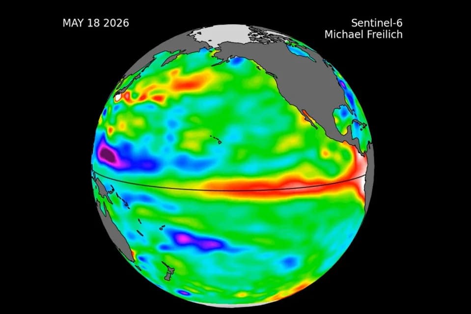
The international Sentinel-6 Michael Freilich sea level satellite observed a swell of warm water, called a Kelvin wave, moving eastward in the equatorial Pacific Ocean, arriving off the South American coast in May.
Satellite measurements reveal a broad surge of unusually warm water sweeping across the equatorial Pacific, a development NASA says could signal the emergence of an El Niño event later this year with significant global consequences.
What the Satellite Saw
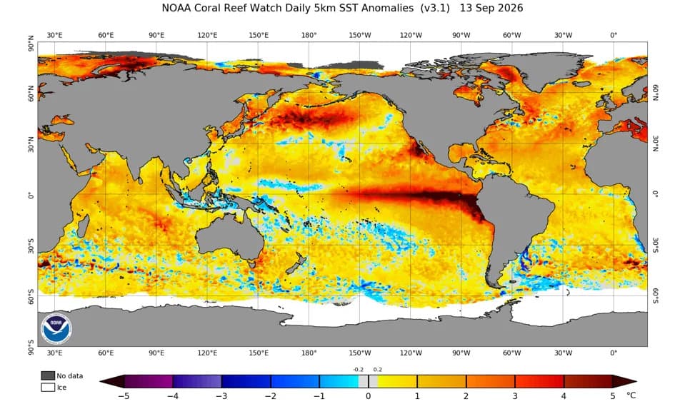
In May, the U.S.-European Sentinel-6 Michael Freilich satellite measured elevated sea-surface heights indicating a mass of warm water stretching for hundreds of miles along the equator and moving eastward toward South America. Because warm water expands, higher-than-normal sea level is a direct indicator of rising ocean temperatures — an early sign of El Niño, NASA researchers say.
Kelvin Waves and How They Form
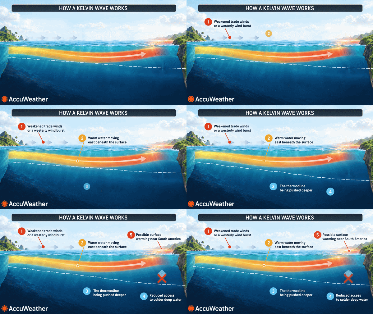
NASA’s report focuses on so-called Kelvin waves: large eastward-moving pulses of warm water that travel along the equator. These waves often form when the prevailing easterly trade winds weaken or reverse, allowing warm water to pile up in the western tropical Pacific. The excess then propagates east over several weeks, raising sea levels and ocean temperatures when it reaches the coast of South America.
According to NASA, a small Kelvin wave formed near Micronesia in late January and dissipated, followed by another wave in early March that continued east. By mid-May, sea levels off Peru were roughly 5.9 inches (about 15 cm) above long-term averages — a notable departure from normal conditions.
"While this year’s event started a bit later than the big El Niños of 2015 and 1997, it’s beginning to catch up," said Josh Willis, a sea level researcher at NASA’s Jet Propulsion Laboratory and project scientist for Sentinel-6.
Why This Matters
An El Niño is the warm phase of the El Niño–Southern Oscillation (ENSO), a natural climate cycle that typically swings every two to seven years. When El Niño develops, it can weaken trade winds, shift rainfall patterns, and alter temperature norms across the tropics — with cascading effects worldwide.
- Regional impacts: Parts of the northern United States and Canada can become warmer and drier, while the U.S. Gulf Coast and Southeast often see wetter conditions.
- Storm seasons: El Niño tends to suppress Atlantic hurricane activity but can enhance tropical cyclone activity in the Pacific.
Scientists warn that if multiple Kelvin waves continue to arrive over the coming months and warm water accumulates off the coasts of Colombia, Ecuador and Peru, the developing event could strengthen into a particularly strong — potentially "super" — El Niño, amplifying its typical impacts.
About Sentinel-6
Launched in 2020 as a joint U.S.-European mission, the Sentinel-6 Michael Freilich satellite provides continuous global measurements of sea-surface height, mapping ocean height roughly every 10 days with precision down to fractions of an inch. This record helps researchers monitor ocean conditions that tend to precede events like El Niño.
NASA and international partners continue to track ocean and atmospheric indicators; ongoing observations over the next several months will be critical to determining whether the current warm pulse develops into a full El Niño and how strong it may become.
Help us improve.