Planet Labs will indefinitely withhold commercial satellite imagery covering Iran and nearby conflict zones at the request of the U.S. government. The company said it will block access to images dating back to March 9 and adopt a case-by-case "managed distribution" system for urgent or public-interest releases. The move expands an earlier 14-day delay and is intended to prevent adversaries from exploiting imagery to target U.S. and allied forces. Other providers have taken different approaches, with Vantor saying it was not contacted and BlackSky not responding.
Planet Labs Will Indefinitely Withhold Satellite Images of Iran and Regional Conflict at U.S. Request
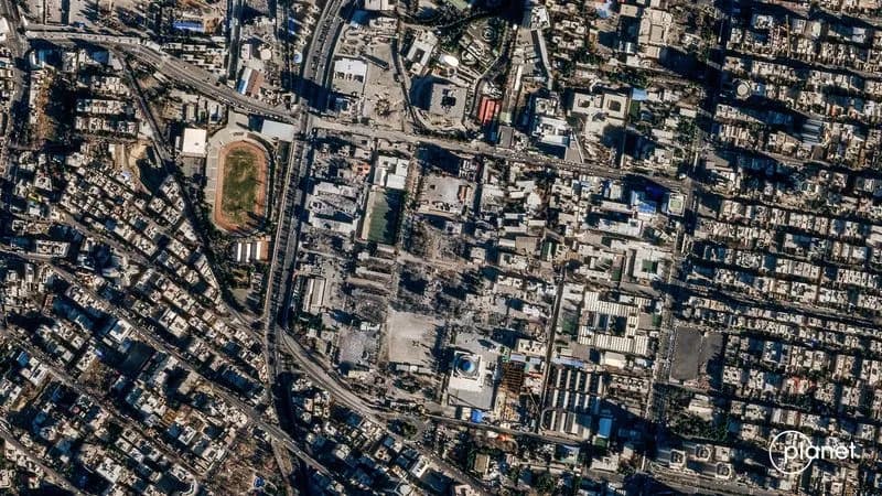
FILE PHOTO: A satellite image shows Iran's Law Enforcement Command (FARAJA) in Tehran, Iran, March 3, 2026, amid the U.S.-Israeli conflict with Iran. 2026 Planet Labs PBC/Handout via REUTERS/File Photo
Planet Labs, the California-based satellite-imaging company, said on Saturday it will indefinitely suspend distribution of commercial imagery covering Iran and surrounding conflict zones in the Middle East to comply with a request from the U.S. government.
In an email to customers, Planet Labs said U.S. authorities asked commercial satellite imagery providers to withhold images of the conflict area on an ongoing basis. The company said the restriction applies to imagery dating back to March 9 and will remain in place until the conflict ends or the policy is otherwise revised.
The move expands a temporary 14-day delay on Middle East imagery Planet Labs imposed last month. The firm said the earlier delay and the current withholding are intended to prevent adversaries from using commercial images to plan or carry out attacks on U.S. forces and allied personnel.
What Planet Labs Will Do
Planet Labs said it will shift to a "managed distribution" approach: imagery deemed safe will be released case-by-case for urgent, mission-critical needs or when publication is judged to be in the public interest. The company added: "These are extraordinary circumstances, and we are doing all we can to balance the needs of all our stakeholders."
Context And Reactions
The regional escalation followed strikes on Iran on February 28, reportedly carried out by the U.S. and Israel, and subsequent Iranian attacks on Israel and U.S. bases in Gulf countries including Saudi Arabia, Kuwait and Bahrain. Military uses of commercial satellite imagery include target identification, weapons guidance, missile tracking and communications; analysts also note that journalists and researchers rely on such images to study hard-to-reach areas.
Other commercial imagery providers have taken varied approaches. Vantor (the company formerly known as Maxar Technologies) told Reuters it was not contacted by the U.S. government but said it reserves the right to implement enhanced access controls during geopolitical conflict and currently applies restrictions over parts of the Middle East. BlackSky Technology did not immediately respond to a request for comment.
Planet Labs operates a large constellation of Earth-observation satellites and regularly sells updated imagery to governments, companies and media organizations. The Pentagon declined to comment on intelligence-related matters, and Planet Labs did not immediately provide additional comment beyond its customer notice.
Why It Matters: Withholding commercial imagery affects transparency and reporting from conflict zones while aiming to reduce the risk that high-resolution images aid hostile operations against U.S. and allied forces.
Help us improve.