NISAR, the joint NASA‑ISRO synthetic aperture radar mission, captured a striking image of East Antarctica showing what looks like a giant hummingbird. The pattern is actually Nunatak Zaterjavshijsja, a mountain peak surrounded by crevasses formed as glacier ice flows around the exposed rock. Radar polarization and advanced processing reveal surface texture and structure through ice and clouds, demonstrating how satellite radar helps scientists map and monitor remote terrain.
NASA‑ISRO's NISAR Captures Giant "Hummingbird" Pattern on Antarctic Ice
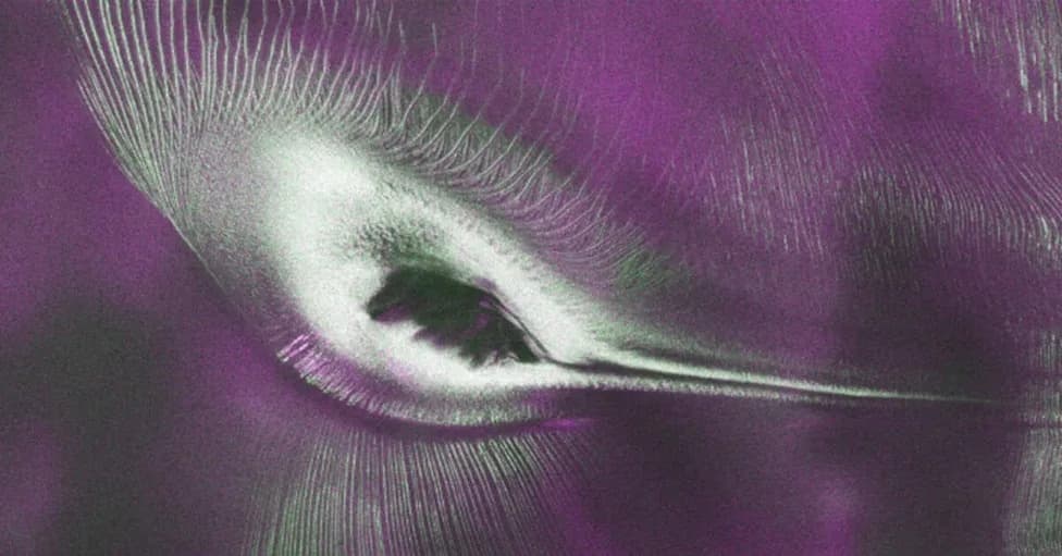
NASA satellite imagery reveals a hummingbird-like formation in Antarctica shaped by glaciers and millions of years of ice movement. | ©Image Credit: NASA
Hidden in Antarctica's vast frozen expanse, a striking formation that looks like a giant hummingbird has been revealed by satellite radar imagery. The feature is not a creature but a natural interplay of rock and moving ice: a nunatak — an exposed mountain peak — surrounded by crevasses that trace a bird‑like outline when viewed from orbit.
How The Image Was Made
The image comes from the NASA‑ISRO Synthetic Aperture Radar (NISAR) mission, a joint effort between NASA and the Indian Space Research Organisation (ISRO). NISAR carries dual radar instruments designed to penetrate clouds, darkness, and ice to map surface structure and motion using microwave signals.
What You're Seeing
The feature identified in the image is Nunatak Zaterjavshijsja, a mountain peak in East Antarctica that protrudes above a broad, flowing ice stream. As the glacier moves toward the ocean, stresses caused by the uneven ground around the nunatak produce deep fractures called crevasses. From above, those crevasses form vivid lines that combine with the nunatak’s silhouette to create the illusion of wings, a body, and a beak.
"Despite its otherworldly quality, the Antarctic image shows a very real geographical feature called Nunatak Zaterjavshijsja, a mountaintop in East Antarctica, poking out amid a stream of ice flowing northeast to the ocean," NASA said.
Why Radar Makes This Possible
Unlike optical cameras, radar instruments send microwaves and record how signals scatter back. Processed radar data can encode polarization differences — for example, vertical versus horizontal reflection — which are often shown as colors such as magenta and green in composite images. Those color differences reveal variations in surface texture, slope, and the orientation of ice and rock, giving scientists clues about the terrain beneath and around the ice.
Scientific Value
Beyond producing an eye‑catching image, NISAR’s radar data are invaluable for tracking glacier flow, measuring land and ice motion, monitoring ecosystems (forests and wetlands), and improving responses to hazards like landslides and earthquakes. Observations like this one demonstrate how spaceborne radar opens new windows into Earth’s most remote and inaccessible places — sometimes producing accidental works of natural art.
Source: FOX Weather; image originally reported on GEEKSPIN.
Help us improve.