Satellite imagery shows China has built detailed, life-size replicas of US warships, allied airbases and Taiwan’s government district across desert training ranges. Analysts say the sites are being used to test long-range and hypersonic missiles, AI targeting systems and to rehearse urban assaults. Observed damage at mock ships and bases indicates multiple successful long-range strikes, heightening security concerns in the Indo-Pacific. Experts call the scale and specificity of the training unprecedented and view it as both technical testing and strategic signalling.
China Builds Life-Size Replicas Of US Warships, Airbases And Taiwan Government Sites To Hone Long-Range Weapons
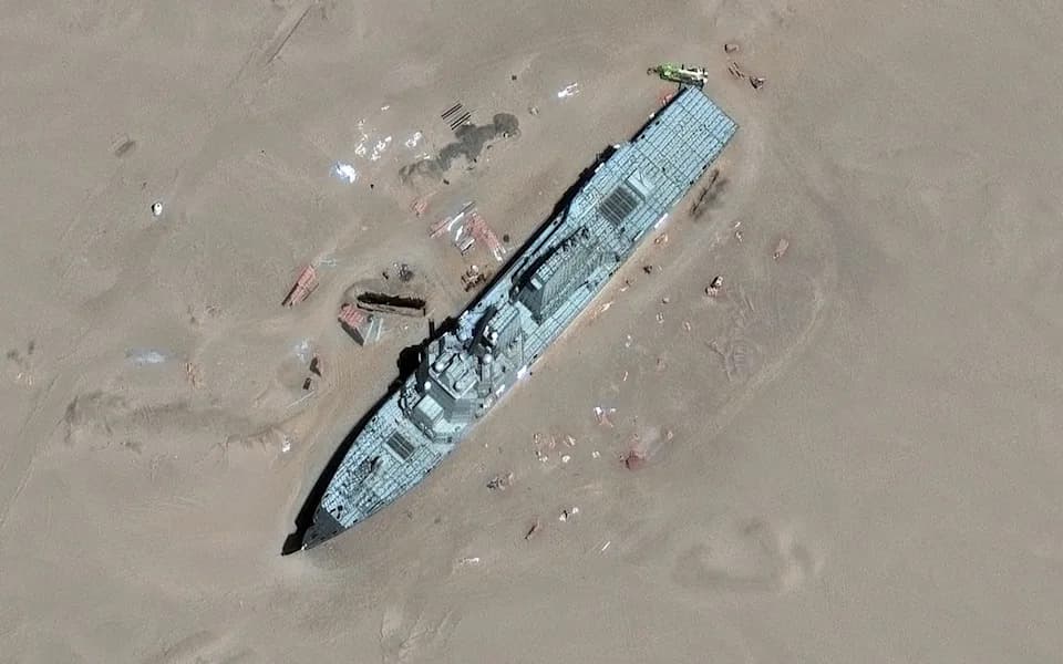
China built a 3-D model of the US Arleigh Burke-class guided missile destroyer to target in a remote desert, as seen here in May.Vantor / Telegraph
Satellite imagery analyzed by international newsrooms shows China has constructed an extensive array of life-size replica warships, aircraft, airfields and government compounds across desert training ranges. Analysts say these mock-ups are being used to test long-range missiles, hypersonic anti-ship weapons and emerging AI targeting systems as Beijing sharpens preparations for a possible contingency involving Taiwan.
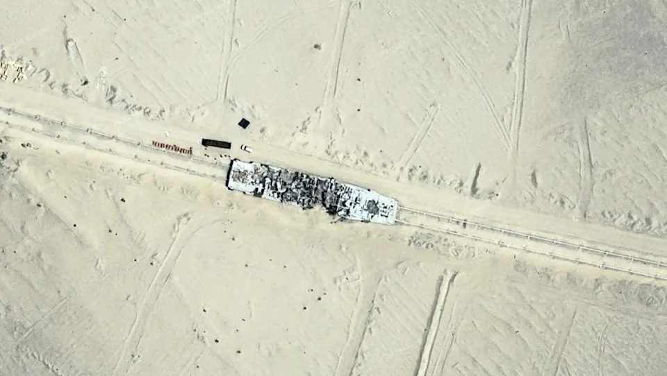
A 23-mile railway provides troops with moving targets like this mock warship.Google Maps
What The Imagery Reveals
Images reviewed by The Telegraph and partners in the Axel Springer Global Reporters Network identify highly detailed targets: a three-dimensional mock-up of an Arleigh Burke–class guided-missile destroyer, replicas of F-35, F-16 and F-22 fighters, and accurate recreations of Taiwan’s Bo'ai Special Zone (the presidential and central government district). Other sites include life-size copies of Japan’s Yokosuka Naval Base and Taiwan’s Su'ao Naval Base.
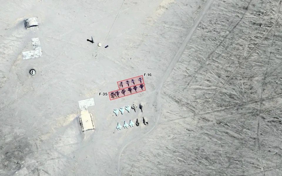
A mock runway in China has replicas of F-35 and F-16 fighter jets, as well as two rows of F-22s nearby.Google Maps
Training Infrastructure And Test Signatures
The ranges incorporate complex features that support realistic testing and rehearsals: a 23-mile railway used to simulate moving maritime targets, a reported 280km tunnel system linking Taiwan-model sites, and rudimentary to highly detailed airbase mock-ups (one near the Jiuquan Satellite Launch Center dates back to about 2002).
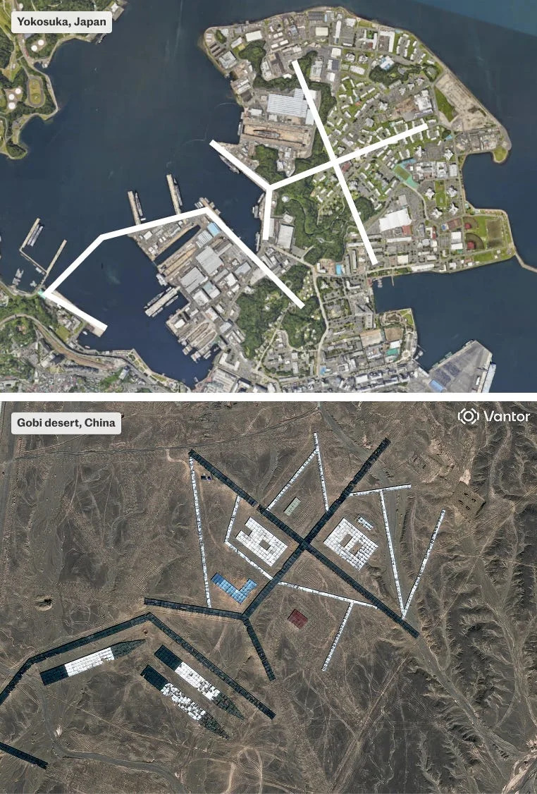
In the Gobi desert, China built a mock-up of the Yokosuka Naval Base — the US's largest naval base in Japan.Top: Google Maps; Bottom: Vantor / Telegraph
Analysts and former military officers point to observable impact craters and damage at several mock sites — including the faux warships and piers — indicating multiple live long-range missile strikes rather than short-range demonstrations. Observers say this pattern demonstrates credible long-range strike capability and realistic end-to-end testing.
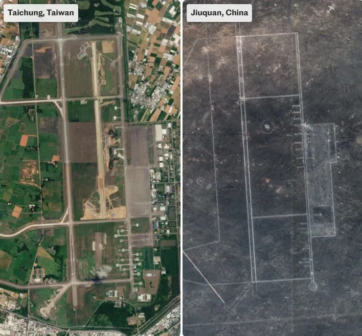
China built a replica of one of Taiwan's largest airbases, which doubles as a civilian airport for Taichung.Left: Google Maps; Right: Vantor / Telegraph
“The accuracy of the replicas signals a highly specific focus on potential adversaries rather than generic capability building,” said Damien Symon, a geo-intelligence researcher at The Intel Lab. Former analysts and officers describe the scale of the training as unprecedented.
Weapons And Purposes
Open-source assessments suggest the exercises are used to validate a range of Chinese systems, including hypersonic anti-ship missiles (reported YJ-21 and YJ-17 variants) and long-range ballistic missiles such as the DF-27. The mock-ups also serve as rehearsal grounds for urban operations simulating seizure of Taiwan’s government facilities and as live-fire targets to calibrate seekers and test warhead effects.
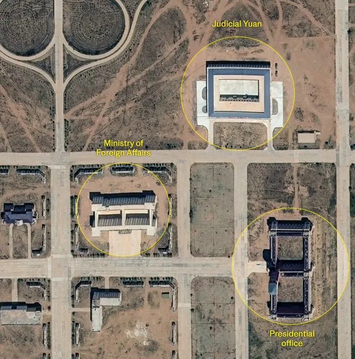
China has built replicas of Taiwan's key buildings.Vantor/Telegraph
Strategic Signalling
Beyond technical validation, the imagery and state-released training footage appear to convey a deliberate strategic message to regional audiences: Japan and US bases modeled at the ranges signal the PLA’s intent to practice strikes against potential external interventions, while the Taipei replicas demonstrate rehearsals for seizing political centers.
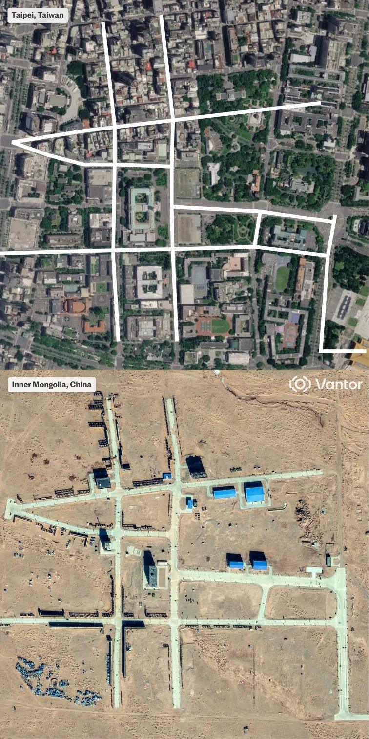
A mock-up in Inner Mongolia closely resembles the layout of Taipei, Taiwan's capital.Top: Google Maps; Bottom: Vantor / Telegraph
What Analysts And Officials Say
Experts quoted in the reporting include satellite-image analysts (Sean O'Connor of Janes), former naval officers (Lu Li-shih, Monty Khanna), and US analysts (Thomas Shugart). US officials have warned that regional militaries are responding with increased defence spending and procurement amid concerns over China’s military build-up.
What This Means: The combination of precise replicas, long-range strike practice and integrated testing (including proximity to test facilities such as Jiuquan) points to deliberate, scenario-specific training. The imagery has raised regional strategic concerns and contributed to heightened defence planning across the Indo-Pacific.
Sources: Satellite imagery and analysis reported by The Telegraph and members of the Axel Springer Global Reporters Network; comments from geo-intelligence analysts and former military officers cited in those reports.
Help us improve.