Paleolatitude.org is a public web tool, developed by Utrecht University researchers, that estimates the ancient latitude of nearly any modern location back ~320 million years. It uses the Utrecht Paleogeography Model, an expanded paleomagnetic frame (gAPWP25) and fine-scale subdivision of orogenic belts to place rocks and fossils more accurately. The site supports batch processing for large fossil datasets and propagates age and paleomagnetic uncertainty, while the authors note remaining regional gaps and typical errors of a few degrees. The team plans to extend the model back to ~550 million years.
Paleolatitude.org — Track Lost Continents and Plate Journeys Over 320 Million Years
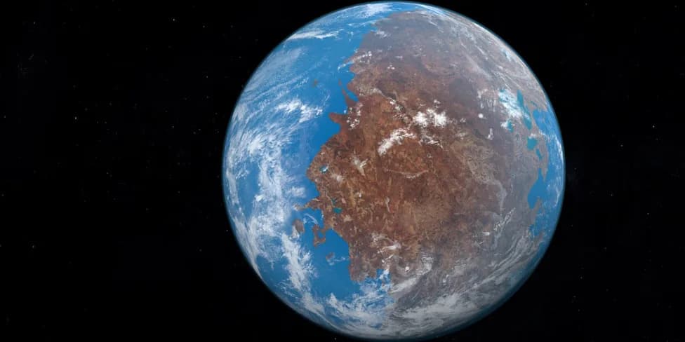
New tool tracks where any place on Earth sat up to 320 million years ago, helping decode ancient climate and fossil records. (CREDIT: Faculty of Geosciences Utrecht University)
Latitude is a fundamental driver of climate because it controls the angle of incoming sunlight — and therefore whether a place tends toward ice, desert, rainforest, or something in between. That simple fact becomes a major complication when rocks, fossils and sediments no longer sit where they formed. A rock collected today in the Netherlands, for example, may have formed thousands of kilometres away on a vanished plate.
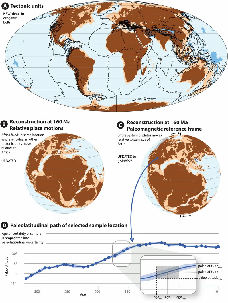
Plate and paleogeographic reconstruction approach underlying the Paleolatitude.org calculator. (CREDIT: PLOS One)
An international team led by Utrecht University earth scientist Douwe van Hinsbergen has launched Paleolatitude.org, an online tool that estimates the paleolatitude of almost any modern location back roughly 320 million years, to the age of Pangea. The database and web interface are built on the Utrecht Paleogeography Model and the updated paleomagnetic reference frame gAPWP25, and the underlying research is published in PLOS One.
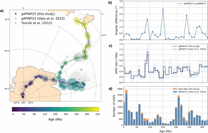
Global apparent polar wander path of Vaes et al. upgraded to gAPWP25. (CREDIT: PLOS One)
How the Tool Works
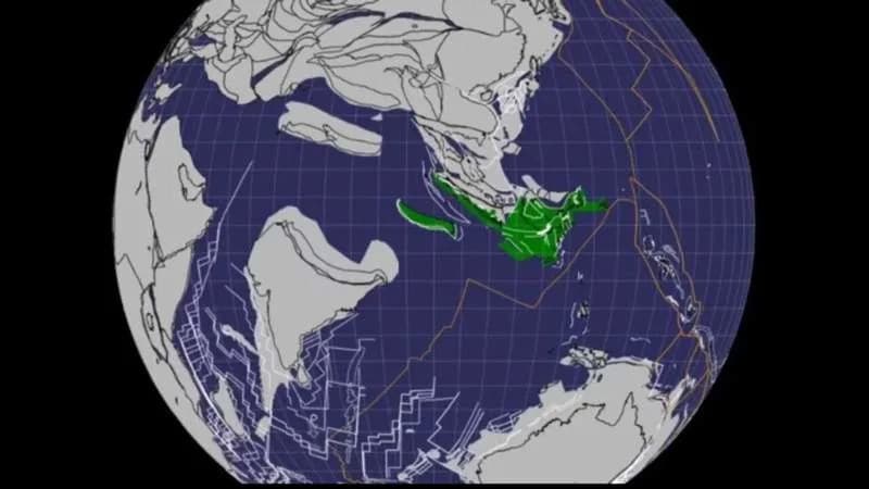
The reconstruction proceeds in two main steps. First, regional and global plate relationships are reconstructed by restoring how crustal fragments, microcontinents and orogenic (mountain-building) belts moved and deformed through time. The new model integrates detailed regional work from the Mediterranean, Iran, the Himalaya and Tibet, Southeast Asia, the Caribbean, and parts of China and Indochina, and explicitly includes lost microcontinents such as Greater Adria, Argoland and the Tethys Himalayas.
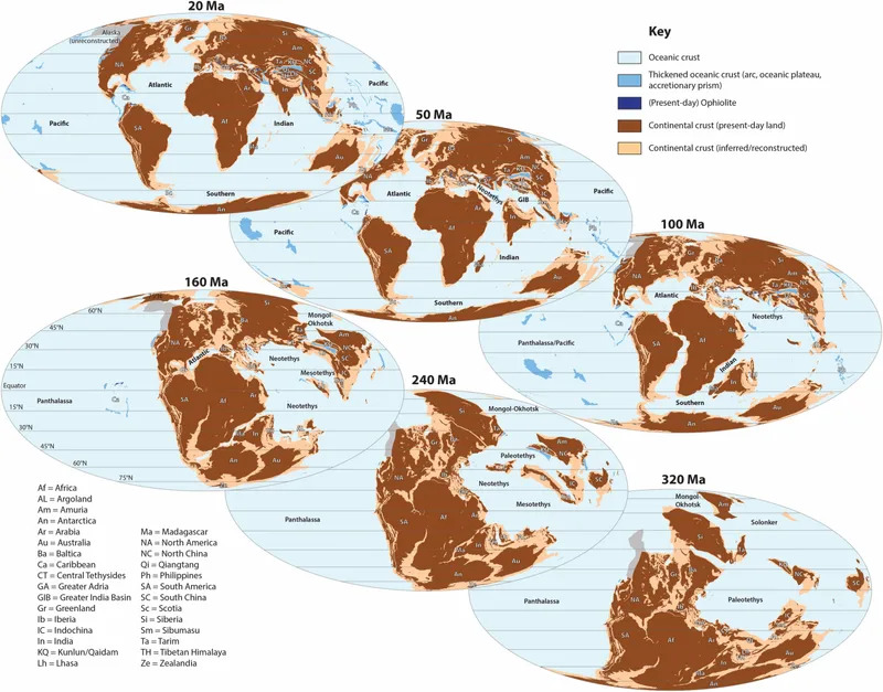
Global paleogeography snapshots of the Utrecht Paleogeography Model that shows the distribution of continental and oceanic crust, placed in the paleomagnetic reference frame based on gAPWP25. (CREDIT: PLOS One)
Second, the entire plate reconstruction is positioned on the ancient globe using paleomagnetism. Magnetic minerals in rocks record the inclination of Earth s magnetic field at formation, which varies predictably with latitude. When paired with age constraints, those measurements let scientists estimate where plates and rocks lay in the past.
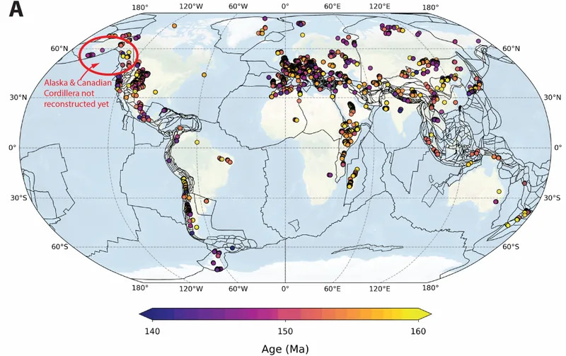
Geographic distribution of the marine fossil dataset from the Upper Jurassic used for to compute a Latitudinal Diversity Gradient. (CREDIT: PLOS One)
What s New in Paleolatitude.org 3.0
- gAPWP25: The paleomagnetic reference frame used by the site adds 32 new entries (about a 10% increase), tightening the global reference path and reducing uncertainty.
- Fine-Scale Orogenic Subdivision: The model subdivides deformed mountain belts into many rigid polygons — sometimes only tens of kilometres across — allowing paleolatitude estimates inside complex regions such as the Alps, Zagros, Himalaya, Japan, New Zealand, and parts of California and Alaska.
- Batch Processing: The public site supports bulk uploads (Excel/CSV) for recalculating paleolatitudes for large fossil datasets while propagating age and location uncertainty. Very large files with tens of thousands of records may take hours to process.
Van Hinsbergen said the advance means a truly global model is now available to link rocks to the original plates that have since been lost into Earth s mantle.
Why This Matters
Paleolatitude is critical for interpreting paleoclimate signals. The Utrecht team highlights Winterswijk (eastern Netherlands), where 245-million-year-old fossils indicate Persian-Gulf-like conditions. Rather than implying a uniformly hotter planet, the fossils make more sense if that region once occupied a much lower latitude. Accurate paleolatitude placement changes how scientists read fossil assemblages, sedimentary environments and chemical proxies.
Because mountain belts often preserve rich fossil and environmental records but are geologically complex, subdividing those belts into many crustal blocks increases the number of reliable paleolatitude estimates. The site s uncertainty model combines errors from the paleomagnetic frame and age constraints, enabling users to propagate realistic error bars through analyses such as latitudinal diversity gradients.
Emilia Jarochowska, a Utrecht paleontologist and co-author, says the tool helps shift biodiversity studies from a one-dimensional focus on time to a three-dimensional view that includes space, improving tests of extinction, migration and refuge patterns.
Limitations And Future Work
- The authors note that reducing complex 3D geological deformation into a 2D global model inevitably loses detail. Small georeferencing errors can place coordinates in the wrong polygon and produce paleolatitude errors of a few degrees in some cases.
- Some regions remain excluded because satisfactory regional reconstructions are not yet available; notable gaps include parts of the Canadian Cordillera, Alaska and pre-late-Cretaceous northeast Siberia. In one example the team omitted ~1,000 fossils from Alaska and the Canadian Cordillera for this reason, which may cause some underrepresentation at certain latitudes.
- Passive margin extension prior to breakup can shift paleolatitude estimates by up to ~2 degrees when north–south rifting is significant.
Despite these caveats, Paleolatitude.org 3.0 represents a significant step toward a more detailed, transparent global framework. The team plans to extend the model back to about 550 million years ago, bringing it into the Cambrian interval when complex life diversified. The public site lets users click on the map or enter coordinates, view up to ten paleolatitude curves at once, and download graphs and data files.
Research findings and data are available in PLOS One and via Paleolatitude.org.
Help us improve.