NASA and ISRO released a NISAR radar image that resembles a hummingbird but actually shows a glacial ice stream flowing around Nunatak Zaterjavshijsja in East Antarctica. NISAR's twin-wavelength radar penetrates snow and ice to reveal crevasses and flow features that optical images miss. The image was published on July 21 as NISAR neared its one-year mark after a July 30, 2025 launch. The mission now revisits nearly all land- and ice-covered surfaces twice every 12 days, producing dozens of terabytes of data daily.
NISAR Radar Image Looks Like a Hummingbird — It's Actually Glacial Ice in East Antarctica
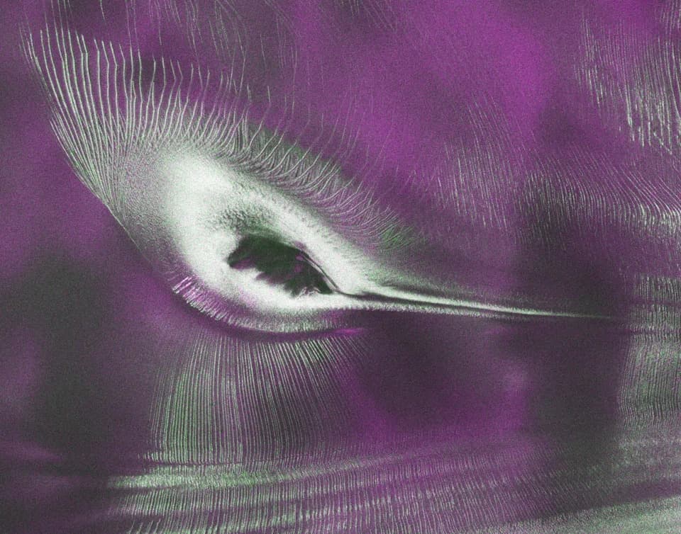
Scientists used data from the L-band radar aboard the U.S.-India Earth-orbiting NISAR satellite to produce this image of Nunatak Zaterjavshijsja, a mountaintop in East Antarctica, poking out amid a stream of ice flowing northeast to the ocean.
A striking satellite image released by NASA and the Indian Space Research Organization (ISRO) shows a pattern that looks remarkably like a hummingbird in flight — but the shape is entirely geological. The image was produced by the NASA-ISRO Synthetic Aperture Radar (NISAR) and reveals a glacial ice stream flowing around the Nunatak Zaterjavshijsja mountaintop in East Antarctica.
How Radar Reveals the Hidden Ice
NISAR carries two radar instruments that operate at different wavelengths, allowing the system to penetrate snow and ice and map structures beneath the surface that optical cameras cannot see. In the radar rendering, the exposed mountaintop forms the hummingbird's "body," while deep crevasses and stress patterns in the surrounding glacier form feather-like "plumage," shown as sharp green lines in the image.
"First, it's a beautiful image, with rich details of features that provide insights to how the glacier is moving. Then, because radar can often see through snow and deep into the ice, NISAR can observe fundamentally different properties of Antarctic ice than can be seen in optical imagery," said Seongsu Jeong, the signal analysis engineer at NASA's Jet Propulsion Laboratory who produced the image. "With NISAR we're seeing what's hidden beneath the surface."
Radar vs Optical Views
NASA also released an optical photo of the same site. The optical view records reflected sunlight and appears largely featureless compared with NISAR's radar image, which highlights flow lines, fractures and subsurface structure. That contrast underscores why radar is so valuable for polar science and glaciology.
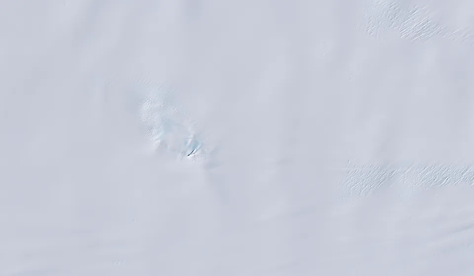
An image from the Landsat 9 satellite shows Nunatak Zaterjavshijsja on Nov. 2, 2025. Because microwaves can penetrate frozen surfaces, signals from NISAR’s L-band radar captured more detail of the structure of the surrounding icescape than is visible in this optical image.
Mission Milestones and Uses
The image was published on July 21 as NISAR approached its one-year milestone following its July 30, 2025 launch from India's Satish Dhawan Space Centre. The satellite now monitors nearly all of Earth’s land- and ice-covered surfaces twice every 12 days and generates dozens of terabytes of data each day.
In its first year, the U.S.–India mission has produced insights ranging from urban street grids and agricultural patterns to landslide and earthquake mapping — and has tracked subsidence in Mexico City. The hummingbird-like image highlights NISAR's ability to produce intricately detailed, scientifically useful imagery that also captures the public’s imagination.
Why it matters: NISAR's twin-wavelength radar provides a new way to observe ice dynamics, crevasse formation and glacier movement — information that helps scientists monitor sea-level rise, glacier stability and the changing polar environment.
Help us improve.