NISAR radar data captured an image of Nunatak Zaterjavshijsja in East Antarctica that strikingly resembles a colorful hummingbird. The dark central area is the mountain summit; the tail-like feature is an ice stream, and the feather-like patterns are crevasses formed by glacier flow. NISAR's radar can probe beneath snow and ice to reveal glacier dynamics, and on July 20, 2026 the mission began releasing its radar data publicly for global research.
Satellite Radar Reveals a 'Hummingbird' Shape on Antarctic Mountaintop — NISAR Image Shows Glacier Flow
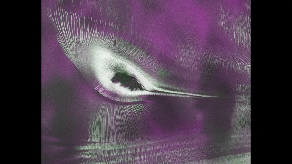
A hummingbird shape in satellite data from NISAR is actually a mountaintop spotted in Antarctica. | Credit: NASA/JPL-Caltech
A striking radar image from the NISAR satellite reveals a formation on an East Antarctic mountaintop that resembles a colorful hummingbird perched on a peak. The visual trick is produced by radar-return contrasts: the dark central area that looks like a bird’s belly is actually the summit of Nunatak Zaterjavshijsja, while the sweeping tail and feather-like patterns are flowing ice and crevasses carved by glacier movement.
What You’re Seeing
The feature that appears to be a tail is an ice stream flowing northeast toward the ocean. The radiating, feather-like patterns are crevasses — fractures in the glacier that form as the ice deforms and moves over and around the nunatak (an exposed mountain peak protruding through ice).
How NISAR Captured It
The image was produced from data collected by NISAR (NASA–ISRO Synthetic Aperture Radar), a joint mission between NASA and the Indian Space Research Organisation (ISRO). Radar instruments can penetrate snow and probe deeper ice structure than optical cameras, revealing subsurface properties and dynamic processes that are invisible in conventional satellite photos.
"First, it's a beautiful image, with rich details of features that provide insights to how the glacier is moving. Then, because radar can often see through snow and deep into the ice, NISAR can observe fundamentally different properties of Antarctic ice than can be seen in optical imagery," said Seongsu Jeong, the signal analysis engineer who produced the image at NASA's Jet Propulsion Laboratory. "With NISAR we're seeing what's hidden beneath the surface."
Public Data Release
On July 20, 2026, NISAR began publicly releasing its radar datasets, enabling researchers worldwide to analyze glacier motion, ice structure, and other Earth-system processes. The mission team plans to continue rolling out additional data products to support climate and cryosphere research.
Why It Matters
Beyond producing a visually arresting image, NISAR's observations can improve understanding of how Antarctic glaciers flow and fracture — information crucial for predicting sea-level change and informing climate research. The combination of high-resolution radar and broad data access makes NISAR a powerful new tool for Earth science.
Help us improve.