Europe’s Mars Express returned high‑resolution HRSC images of Shalbatana Vallis on May 13, revealing chaotic collapsed blocks and broad valleys carved by catastrophic floods about 3.5 billion years ago. The main channel is roughly 6 miles (10 km) wide and 1,640 feet (500 m) deep, and layered deposits suggest parts of the valley were later filled by sediments and volcanic ash. These features strengthen interest in low‑lying areas such as Chryse Planitia as potential sites of an ancient ocean and preserve clues to Mars’ wetter past.
Mars Express Reveals Chaos Terrain and Flood‑Carved Canyons in Shalbatana Vallis
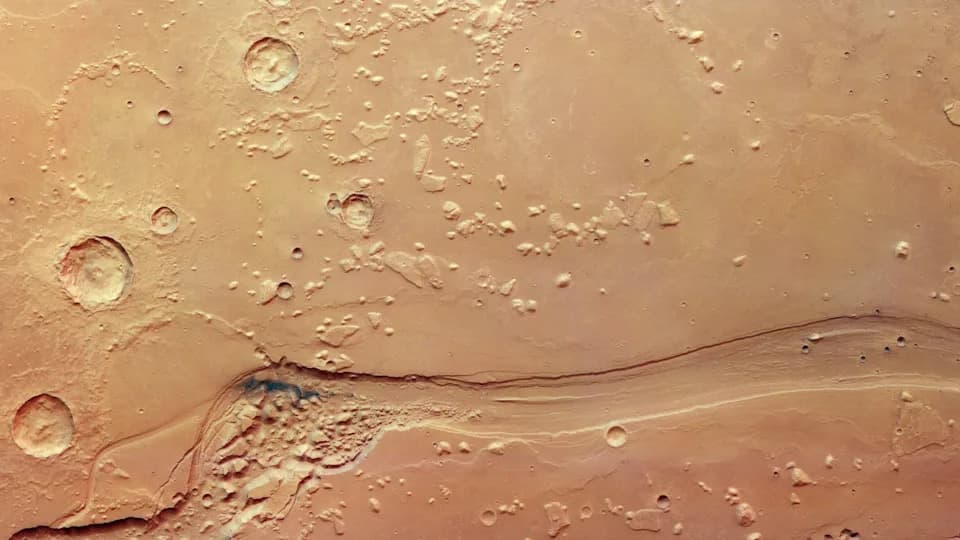
A new image from ESA's Mars Express shows part of Shalbatana Vallis, a large channel in Mars's equatorial region. | Credit: ESA/DLR/FU Berlin
Stunning new images from Europe’s Mars Express orbiter reveal a rugged Martian landscape carved by catastrophic floods billions of years ago. The European Space Agency (ESA) released the view on May 13, based on data from the orbiter’s High Resolution Stereo Camera (HRSC), highlighting the fractured, blocky 'chaotic terrain' of Shalbatana Vallis.
Shalbatana Vallis is a sprawling channel system near Mars’s equator that extends roughly 800 miles (1,300 kilometers)—about the length of Italy. The main channel visible in the new images spans about 6 miles (10 kilometers) across and drops roughly 1,640 feet (500 meters) from rim to floor.
Chaotic terrain consists of disrupted, jumbled plates of rock believed to form when subsurface ice melted and the overlying ground collapsed. In Shalbatana Vallis, those broken blocks sit alongside sinuous valleys that planetary scientists interpret as the scars of massive floods that swept across Mars around 3.5 billion years ago.
"This kind of terrain is common on Mars, and has been captured before by Mars Express," ESA officials said.
Researchers infer that large volumes of groundwater burst onto the surface in repeated, high‑energy outflows, rushing downhill and rapidly carving the broad channels now visible. The HRSC pictures expose layered records of the region’s geological history, suggesting Shalbatana Vallis may once have been even deeper before sediments, volcanic ash and other deposits gradually filled parts of the valley.
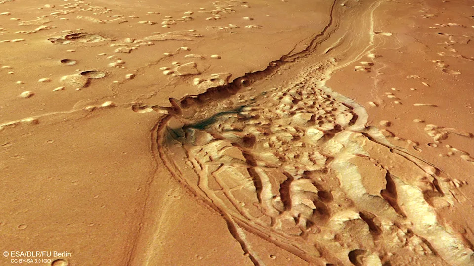
Mars Express imagery of a part of a small patch of chaotic terrain within Shalbatana Vallis, a large channel near Mars's equator. | Credit: ESA/DLR/FU Berlin
Dark blue‑black deposits peppering the valley are interpreted as volcanic ash redistributed by Martian winds. Scattered impact craters, wrinkle ridges and isolated mesas point to repeated cycles of catastrophic flooding, lava emplacement and erosion over billions of years.
Why Scientists Care
Places like Shalbatana Vallis preserve evidence that Mars was once considerably warmer and wetter. The channel system drains toward Chryse Planitia, one of the planet’s lowest basins and a prime candidate region in studies that propose an ancient Martian ocean.
About Mars Express
Launched in 2003, Mars Express is one of the longest‑operating missions at Mars. For more than two decades its HRSC has been mapping the Red Planet in color and 3D, contributing to discoveries of water‑formed minerals, buried ice deposits and other clues to Mars’ watery past. The mission has also provided data relevant to debated findings that hint at possible liquid water beneath the southern polar ice cap.
Bottom Line: The new HRSC images of Shalbatana Vallis enrich our understanding of Mars’ violent watery past and help scientists target regions that may preserve sediments or other markers of past habitable environments.
Help us improve.