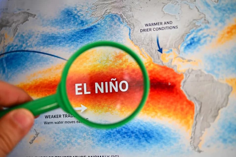
Climate models now point to a rapidly intensifying "super" El Niño that could rival major events of 1982–83, 1997–98 and 2015–16. For Washington, D.C., expect a more humid, storm-prone late summer, a wetter autumn with gradual drought relief, and an overall milder winter in 2026–27. However, history shows that strong El Niños can still produce one or two dramatic snowstorms if cold air and a moisture-rich storm track align — creating a boom-or-bust snowfall season. Forecasters will monitor sea-surface temperatures and storm tracks closely as models refine the event's strength and timing.
A 'Super' El Niño Is Forming — What It Could Mean for Washington, D.C.'s Weather
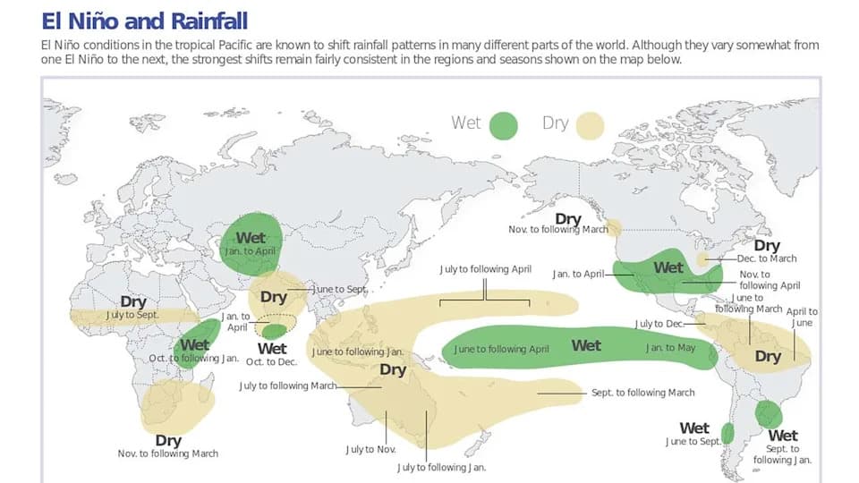
The impacts of an El Niño event are different throughout the world, as the above Columbia University/NOAA graphic shows.
Forecasts increasingly point to a rapidly intensifying "super" El Niño in the tropical Pacific that could rival some of the strongest events on record. Climate models from major centers now suggest this episode may match or exceed powerful El Niños such as 1982–83, 1997–98 and 2015–16.
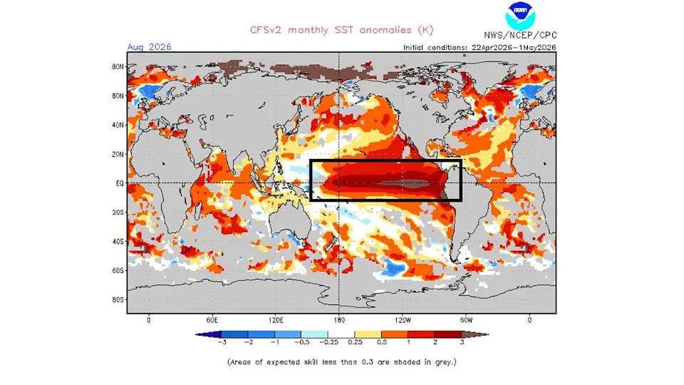
NOAA’s Climate Forecast System showing an intense, strong El Niño in the Pacific Ocean by August 2026. Source: NOAA
What Is a "Super" El Niño?
El Niño is a natural climate pattern characterized by abnormally warm sea-surface temperatures in the central and eastern tropical Pacific. Strong or "super" El Niños amplify global weather impacts by shifting the jet stream and storm tracks, altering precipitation and temperature patterns across many regions.
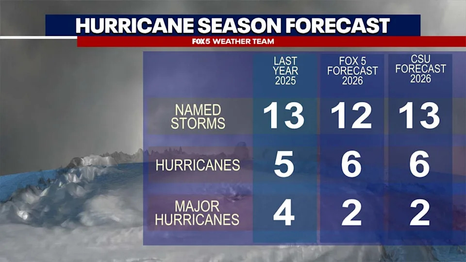
While NOAA’s Offical Hurricane Forecast does not release until May 21st, most hurricane outlooks from other establishments including Colorado State University (CSU) are pointing towards below normal activity this hurricane season.
Historical Context
Scientists compare the current development to several historic strong events. The 1877–78 episode, reconstructed by reanalysis, is thought to be among the most intense, though observational data from that era are limited. That event coincided with catastrophic droughts and famines across Asia and South America, contributing to an estimated tens of millions of deaths. More recently, the super El Niños of 1982–83, 1997–98 and 2015–16 each produced very different regional outcomes in the United States — from blockbuster snowstorms to unusually warm, wet winters.
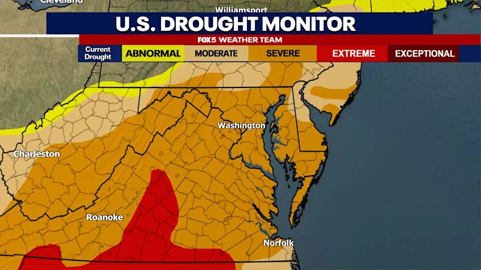
The Drought Monitor for our region as of early May 2026, showing most of our region in a severe drought.
Summer Outlook For the Mid-Atlantic
El Niño’s summer signal in the Mid-Atlantic is generally weaker than its winter influence, but a strong event can still affect the season:
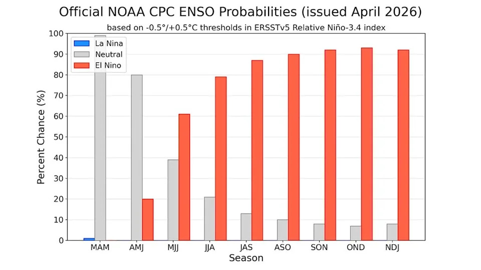
NOAA has an 80% chance of El Niño conditions by the summer months, rising to a greater than 90% chance by the fall. Source: NOAA
- Increased humidity and more frequent rounds of thunderstorms, especially late July–August
- Warmer nights with reduced overnight cooling
- Heavier, moisture-rich storms that can raise flash-flood risk locally
Because convective summer storms are highly localized, rainfall can remain uneven: one neighborhood may see several inches while a nearby area remains dry. That said, more frequent storms could begin to chip away at the region’s drought, though meaningful recovery typically requires repeated wet seasons or large widespread events.
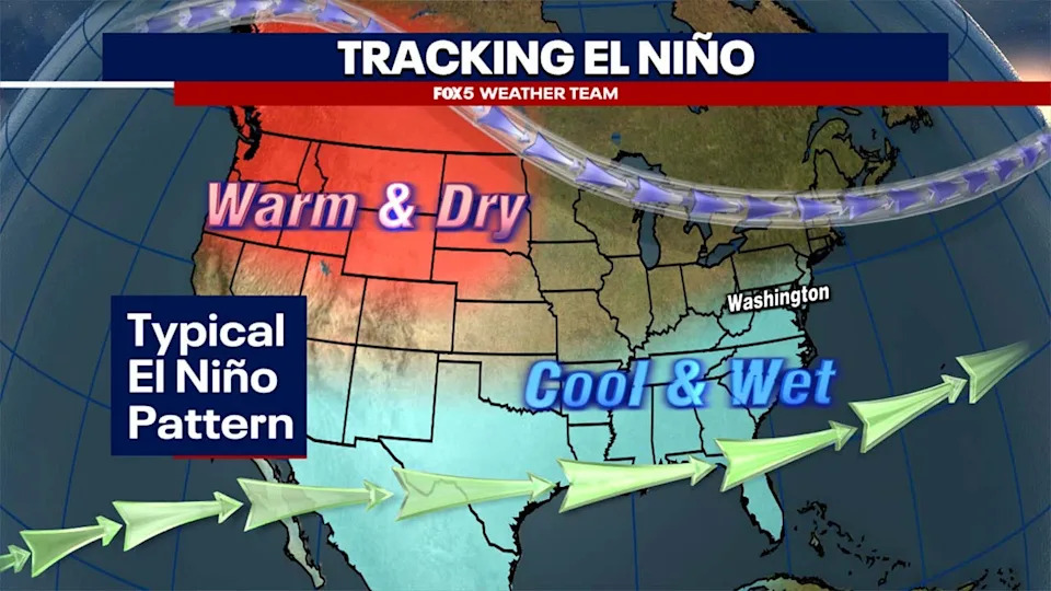
The winter pattern during an average El Niño event, though stronger El Niño cases are noted to come with much milder conditions for most of the country with a much stronger tropical jetstream.
Hurricane Season
Strong El Niños usually increase upper-level winds across the tropical Atlantic, raising vertical wind shear that hinders hurricane development. This typically reduces the number and intensity of Atlantic hurricanes, but it does not eliminate risk — a single storm with the right track can still threaten the East Coast. Forecasters will monitor sea-surface temperatures closely, since unusually warm waters can partially offset El Niño’s suppressing influence.
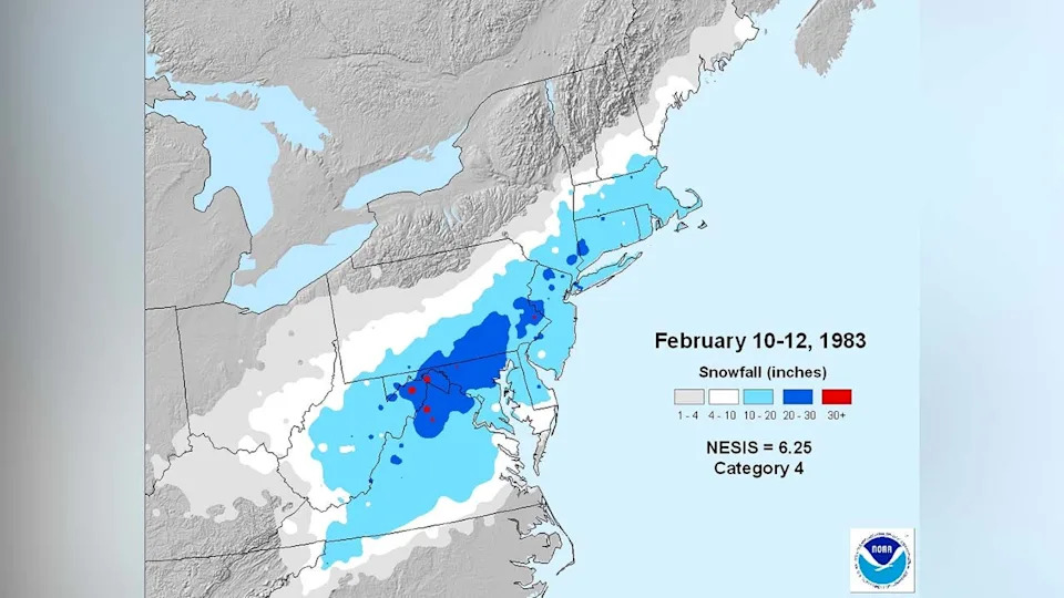
Snowfall during the February Blizzard of 1983. Source: NOAA
Autumn And Drought Recovery
El Niño frequently strengthens its influence in fall. For the Mid-Atlantic this often means a more active coastal storm track and above-average precipitation through autumn and into winter, which can support gradual drought improvement. However, deep long-term deficits rarely vanish after one season.
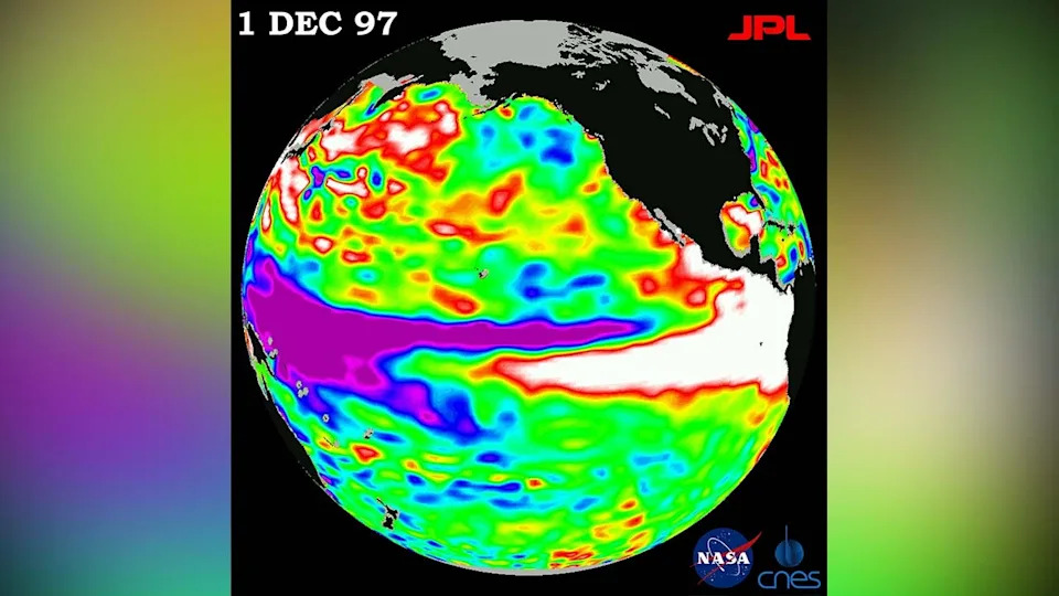
Satellite data showing the super El Niño event in December of 1997. Source: NASA
Winter Expectations
Winter impacts are where strong El Niños usually show their clearest signal: overall milder temperatures across much of the eastern U.S. and a southward-shifted, active storm track that favors coastal storms and nor'easters. Historic super El Niños illustrate two important takeaways:
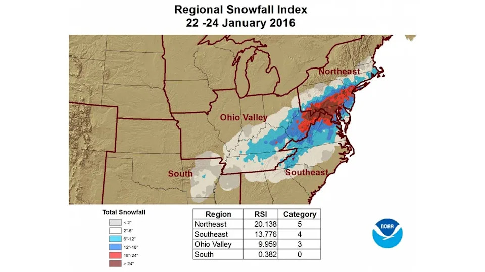
Snowfall data from the Blizzard of January 2016. Source: NOAA
- Winters tend to be milder on average.
- Major snowstorms remain possible when cold air and a moisture-rich storm track align — producing a "boom-or-bust" snowfall season.
Examples: 1982–83 brought both a generally mild season and the Blizzard of February 1983; 1997–98 was unusually warm with almost no snow in Washington, D.C.; and 2015–16 combined a warm winter overall with a powerful January blizzard. If the current event reaches "super" strength, a higher probability of a mild winter in 2026–27 is likely, but the potential for one or two historic coastal snowstorms would remain.
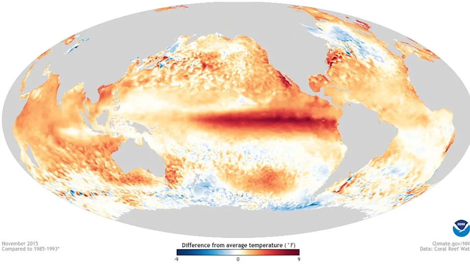
The most recent Super El Niño of 2015-2016, the strongest in recorded history for which reliable weather data exists, could offer a very similar analog to what the upcoming fall and winter potential could be. Source: NOAA
What This Means For Washington, D.C.
- Stormier, more humid late summer with more frequent thunderstorms
- Wetter autumn with improved chances for drought relief, though recovery may be slow
- Likely quieter Atlantic hurricane season overall, but East Coast risk persists
- An active but generally milder winter, with heightened nor'easter potential and an outside chance for isolated historic snow events
Bottom line: A developing super El Niño could reshape Mid-Atlantic weather for the coming year. While trends point to a milder winter and wetter fall, localized extremes — heavy summer storms or a single significant coastal snowstorm — remain possible. Meteorologists will continue to monitor sea-surface temperatures and model guidance and update forecasts as the event evolves.
Sources: FOX 5 Weather Team, National Weather Service, and peer-reviewed reanalysis studies cited by climate centers.
Help us improve.