Movable yellow concrete markers known as the 'Yellow Line' are being shifted by Israeli forces to expand a restricted zone across Gaza, which OCHA says covered 64.9% of the territory by June 2026. Residents and humanitarian agencies report repeated forced displacement, loss of farmland and homes, and at least 1,168 Palestinian deaths since last October, with many fatalities near the advancing line. Analysts and an Al Jazeera investigation say the pattern of new military outposts and watchtowers risks turning temporary positions into entrenched control, while humanitarian access remains limited at roughly 35% compliance.
‘Creeping Death’: How Israel’s 'Yellow Line' Is Redrawing Gaza and Forcing Displacement
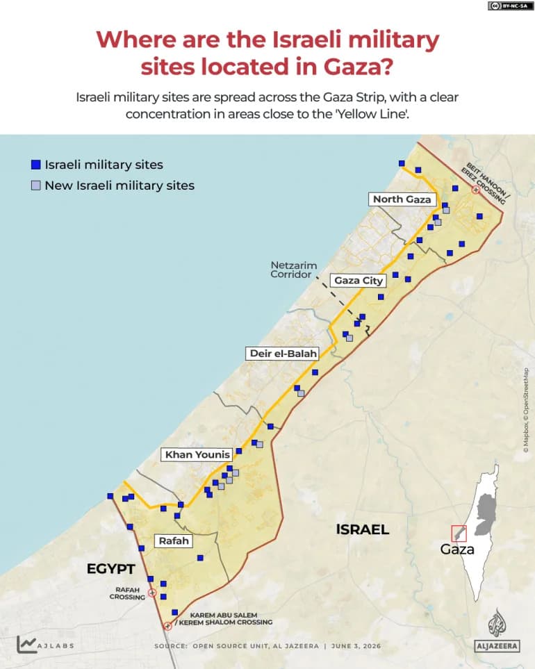
INTERACTIVE - Where are the Israeli militarybases located in Gaza - JUNE3, 2026-1780480693
In Gaza, movable yellow concrete markers — referred to by residents and humanitarian agencies as the 'Yellow Line' — have been shifted by Israeli forces to expand a restricted zone across large swathes of the territory. According to the UN Office for the Coordination of Humanitarian Affairs (OCHA), the area defined by this line grew to cover 64.9% of the Gaza Strip by June 2026, up from 53% earlier in the year.
What the 'Yellow Line' Is
Originally placed as field markers after a ceasefire to separate Israeli positions from areas slated for withdrawal, these concrete blocks have effectively become a moving frontline. Humanitarian and media reports say the markers are being used to create a de facto and progressively expanding restricted zone on the ground.
Field Reports and Human Cost
Gaza’s Government Media Office has recorded 3,795 alleged ceasefire violations and reports 1,168 Palestinian deaths since the ceasefire went into effect in October. United Nations data indicate roughly a third of those fatalities occurred in areas adjacent to the advancing demarcation line.
On the night of July 17, residents in eastern Deir el-Balah reported that Israeli quadcopters broadcast evacuation orders while military vehicles pushed the yellow blocks 300–350 metres westward. The sudden movement placed barriers on Sultan Othman Street and cut off farmland and homes belonging to local families.
'The yellow cube is now placed two to four metres from citizens' homes,' Hazem Saeed told Al Jazeera, describing families who have lost agricultural land and livelihoods.
In Gaza City’s Zeitoun neighbourhood, 71 displaced families set up a makeshift camp on Salah al-Din Street roughly 70 metres from the line. Camp supervisor Ramadan Abu Ammo told reporters they had no safe alternatives and that shrapnel falls frequently. He added that rescue teams are barred from entering newly restricted areas, leaving some relatives trapped under rubble.
'The advancing blocks are a creeping death,' said Palestinian journalist Saed Hassaballah, describing how intense gunfire and shelling often precede the markers' movement and force residents to abandon homes.
Wider Clearance, Surveillance and Detentions
In northern Gaza, residents report the line has advanced up to 1.5 km in places, with bulldozers flattening homes and quadcopters demolishing remaining structures. Local testimony describes large earthen embankments and watchtowers on high ground that provide direct surveillance over neighbourhoods.
There are also reports of local armed groups aligned with Israel detaining and assaulting youths near the line, then handing detainees over to Israeli forces, according to witnesses in Beit Lahiya and other localities.
Impact On Services And Population Density
Municipal officials say the advancing line has paralysed civil life across Gaza. Mohammed al-Sarsawi, head of media for Gaza municipality, told Al Jazeera municipal teams can no longer access nearly half of Gaza City, including Shujayea, eastern Tuffah, Zeitoun and parts of Daraj. Key water wells, sewage facilities and control rooms have been isolated, increasing the risk of prolonged environmental and health crises as more than half of Gaza City's roughly 950,000 residents are compressed into a shrinking area.
Evidence Of Entrenchment And Political Signals
Analysts warn that the pattern of creating military posts and permanent positions along the line resembles past processes by which temporary military control became long-term occupation. Political analyst Ahmed al-Tanani said the territory under effective Israeli control appears to be expanding from an estimated 195 sq km to about 235 sq km.
An investigation by Al Jazeera's Open Source Unit identified 40 permanent Israeli military outposts across Gaza, several reportedly constructed after the ceasefire. Public remarks by Israeli officials have also signalled an intent to solidify control: National Security Minister Itamar Ben-Gvir was quoted celebrating the expansion and saying, 'Gaza is ours.'
Humanitarian Access
Humanitarian aid deliveries into Gaza and civilian movement out of the territory remain constrained. Reports indicate Israel's compliance rates for aid and movement approvals are roughly 35%, leaving many communities with limited access to assistance and safe passage.
Implications
Residents, aid agencies and analysts say the practice of moving the 'Yellow Line' is producing repeated displacement, loss of livelihoods and increasing isolation of critical infrastructure. The combination of physical barriers, surveillance positions and restricted humanitarian access has raised concerns that temporary arrangements on the ground could become long-term changes to Gaza’s geography and governance.
Sources: Office for the Coordination of Humanitarian Affairs (OCHA), Gaza Government Media Office, Al Jazeera reporting and Open Source Unit, on-the-ground eyewitness accounts.
Help us improve.