Researchers at the University of Arizona mounted ground-penetrating radar on small drones and successfully mapped debris-covered glaciers in Alaska and Wyoming, detecting thin surface debris layers and internal ice structure. The tests validated radar results with excavations, drilling, and simulations and established operational parameters such as flight altitude and speed. Applied to Mars, drone-based radar could identify shallow, accessible water ice and guide drilling sites, complementing orbital and surface assets. The study was published March 24 in the Journal of Geophysical Research: Planets.
Drone-Mounted Radar Could Pinpoint Where to Drill for Water on Mars, Study Finds
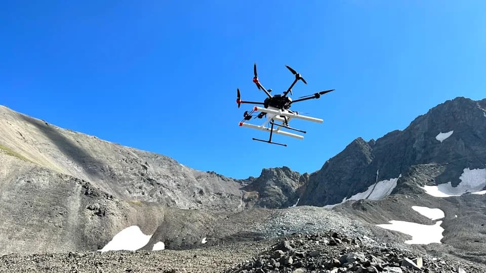
Silhouetted against the blue sky, a drone carrying a ground-penetrating radar instrument lifts off from Galena Creek Rock Glacier in Wyoming. | Credit: Jack W. Holt
A new study led by researchers at the University of Arizona demonstrates that small drones equipped with ground-penetrating radar can map buried ice with fine detail — a capability that could be adapted to help future Mars missions find accessible water ice for science and human exploration.
Earth Tests Provide a Blueprint
The team tested drone-mounted radar over debris-covered glaciers in Alaska and Wyoming that resemble ice deposits detected on Mars. Flying low and slow, the drones produced high-resolution subsurface maps that revealed ice thickness, internal layering, and debris covers only a few feet thick. The radar interpretations were validated by field excavations, shallow drilling, and forward modeling to confirm the signals originated beneath the surface debris.
A research drone equipped with ground-penetrating radar takes off for a reconnaissance flight on Galena Creek Rock Glacier, Wyoming. | Credit: Michael Daniel
Why This Matters for Mars
Orbital radar instruments such as SHARAD (Shallow Radar) on NASA’s Mars Reconnaissance Orbiter have proven there is abundant subsurface ice on Mars, especially at mid-latitudes. However, orbiters lack the resolution to determine shallow details that are essential for planning drilling or resource-extraction operations — for example, whether ice sits under one meter of loose debris or tens of meters of compacted material. Drone-based radar could fill that gap by producing localized, high-resolution surveys that identify where ice is most accessible.
“If you want to make decisions about where to drill on Mars, you need to know if the ice you're trying to find is under one meter of debris or ten,” said Roberto Aguilar, the study’s lead author and a doctoral researcher at the University of Arizona Lunar and Planetary Laboratory. “That's the kind of information a drone-based system could provide.”
Operational Insights and a Layered Strategy
The tests also established practical operational parameters: optimal flight altitude and speed, the benefit of flying along glacier flow lines, and the importance of radar alignment to maximize subsurface detection. Rather than replacing orbiters or rovers, drone scouts could act as an intermediate layer in a staged exploration strategy — orbiters identify broad regions, drones refine maps at high resolution, and surface missions drill and analyze samples — reducing risk and improving mission efficiency.
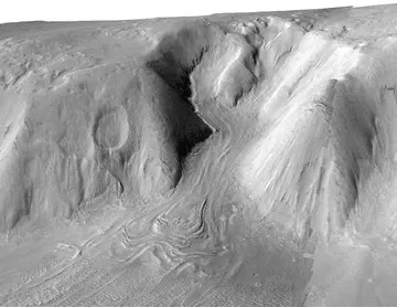
This stereo image taken by the HiRISE camera aboard the NASA Mars Reconnaissance Orbiter shows a viscous flow feature in Deuteronilus Mensae, a region on Mars believed to contain large amounts of ice. | Credit: HiRISE/CTX
Scientific And Practical Implications
Beyond logistics, locating near-surface water ice has major scientific and exploration implications. Martian ice preserves records of past climate and may hold chemical signatures relevant to the search for past life, while also serving as a resource for drinking water, oxygen, and fuel for future crews. The concept builds on demonstrations of aerial flight on Mars by NASA’s Ingenuity helicopter and points toward more capable aerial platforms for subsurface reconnaissance.
Publication: The study was published March 24 in the Journal of Geophysical Research: Planets.
Help us improve.