
The Technical University of Munich published the GlobalBuildingAtlas, a public 3D map that locates 2.75 billion buildings using satellite imagery and machine learning. The dataset uses a 3×3 metre grid—about 30× finer than prior global footprint databases—and supplies volumetric models for most structures. Researchers introduce the building volume per capita metric to reveal housing and infrastructure disparities and note limitations, including underestimates of high-rise heights and gaps in African validation data.
GlobalBuildingAtlas: A 3D Map of 2.75 Billion Buildings That Changes Urban Planning

3D building map
Researchers at the Technical University of Munich (TUM) have published the GlobalBuildingAtlas, the largest global 3D building dataset to date, locating 2.75 billion structures worldwide.
The atlas was produced by combining an immense archive of satellite imagery with machine-learning models that use measured building heights where available and infer heights where they are not. The dataset maps the planet on a 3-by-3 metre grid, capturing building size and volume at roughly 30 times finer spatial detail than previous global footprint databases.
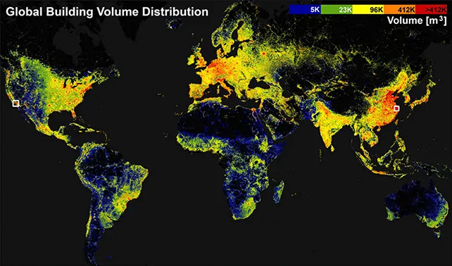
The atlas enabled the researchers to map building density across the globe. (Zhu et al.,Earth Syst. Sci. Data, 2025)
What the Atlas Shows
The GlobalBuildingAtlas provides volumetric 3D information for nearly every mapped structure, enabling new ways to measure urban form. Instead of relying solely on 2D footprints, analysts can measure building volume and calculate metrics such as building volume per capita to reveal housing and infrastructure disparities.
"3D building information provides a much more accurate picture of urbanization and poverty than traditional 2D maps," said Xiaoxiang Zhu, data scientist at TUM. "With 3D models, we see not only the footprint but also the volume of each building, enabling far more precise insights into living conditions."
Uses and Applications
Planners, policymakers and researchers can use the atlas to improve climate adaptation planning, disaster preparedness, infrastructure investment, and the delivery of public services such as hospitals and schools. The volumetric approach also helps refine population density estimates and supports progress toward the United Nations' 2030 Sustainable Development Goals for inclusive, safe and resilient cities.

Subscribe to ScienceAlert's free fact-checked newsletter
Limitations and Future Work
The dataset relies on machine-learning inference, so regional biases remain. The authors note that parts of Africa need more training data and ground validation, and that heights for high-rise buildings tend to be underestimated in many areas. The team plans ongoing improvements to training data, validation, and model performance to increase accuracy and utility.
"Buildings anchor human life and define the form and function of urban environments," the authors write in their paper. "3D insights are essential for urban planning, infrastructure management and policy-making—especially in resource-limited contexts where the strategic allocation of funding and intervention is critical."
The GlobalBuildingAtlas is accessible online and the research has been published in the journal Earth System Science Data.


